 Climate of the Thousand Islands Climate of the Thousand Islands
By S. Lapczak, W.D. Wyllie, and R.G. Lawford Original Manuscript Copyright ©1979 Parks Canada. This report is a condensed form of climatological analysis undertaken by Atmospheric Environment Service for Parks Canada, the Department of Indian and Northern Affairs in March, 1977. Recognition for all information should be given to the authors of the original report "Climate of the St. Lawrence Islands National Park", notably S. Lapczak, W.D. Wyllie, and R.G. Lawford. Reproduced by permission of St. Lawrence Islands National Park. See also A Natural Heritage Review of the Thousand Islands Ecosystem
Table of Contents 1. Introduction 2. Climate of St. Lawrence Islands National Park
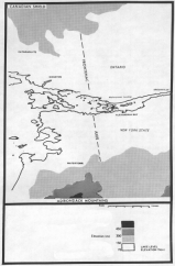
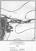
3. Conclusion 1. Introduction [Top] 1.1 Location [Top] The St. Lawrence Islands National Park is located in the Thousand Islands situated in the St. Lawrence River near the northeast corner of Lake Ontario. St. Lawrence Islands National Park (SLINP) includes 21 islands, 85 rocky islets as well as the river bank at Mallorytown Landing. Figure 1.1 shows the topography of the St. Lawrence Valley and the areas surrounding the park.
1.2 Climate and Climatic Controls [Top] In the broadest sense, climate is the characteristic condition of the atmosphere near the earth's surface at a given place or over a given region. Components that enter into the description and classification of climate are mostly the same as weather components used to describe the state of the atmosphere at a given instant. The physical components of climate are many; they include such measurable quantities as net radiation, sensible heat, barometric pressure, winds, relative and specific humidity dew point, cloud cover and type, fog, precipitation, incidence of cyclones and anticyclones, and frequency of frontal passages. All climatic differences are traceable to the differential
heating of the earth's surface due to the fact that the sun's
rays do not fall with equal intensity upon all parts of the globe.
This, together with an inequality in rates of absorption of head
by land and water, gives rise to air currents or winds, which
exert an important influence on the climate. In these terms,
the chief factors which control the climate of the St. Lawrence
Islands National
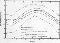
Latitude and Solar input: the influences of distance north or south of the equator is seen in the seasonal variation in length of days and in the difference in the amount of heat received from the sun. The position of the sun determines the duration and effectiveness of solar heating of the area by controlling the length of days and angle of incidence of the sun's rays. Topography: the topographic climatic controls within SLINP are basically the result of the channelling effect of the St. Lawrence Valley. Figure 1.1 shows that the St. Lawrence Valley is narrowest where the river cuts through the Frontenac Axis. This Axis joins the Canadian Shield to the Adirondack Mountains of New York State. Further to the northeast, beyond the Axis, the Valley broadens. The river remains approximately 10 km wide through the Frontenac Axis and narrows to the northeast. Therefore, in the vicinity of SLINP, the valley channels the wind flow along the river. The flow spreads the effects of Lake Ontario further along the St. Lawrence River than would otherwise be the case. The Lakes: land surfaces heat up more quickly and cool off more rapidly than does water, hence the presence of large bodies of water tends to stabilize the climate of a region. Climates in which the land influence is predominant are called continental, while those controlled by the presence of water are called marine. The maritime effect of the Lakes, more specifically of Lake Ontario and the southwestern portion of the St. Lawrence River, are the predominant factors in SLINP's region. The mere presence of the Great Lakes provides one of the major climatic controls affecting this region. With a volume of 22,500 km exposed over a surface area of 243,000 square km, the lakes act as a vast reservoir for the storage and subsequent exchange of heat energy with the atmosphere. The lakes significantly moderate the temperature regimes over adjacent land areas. Proximity of the Paths of Air Masses: between 35º and 65ºN latitude is found the northern zone of westerly winds and cyclonic storms (or low pressure system). Areas of low pressure, originating over western North America and the Pacific Ocean, follow several preferred tracks across the continent, which by swinging north or south with the seasons, usually leave the continent by way of the St. Lawrence Valley and the Maritime Provinces, thus bringing to southern Ontario exceedingly variable and constantly changing types of weather. The frequent variations, in direction and speed of the winds and other changes in the weather over Lake Ontario, for example, are due to the many low and high pressure systems which traverse the area. 2. Climate of St. Lawrence Islands National Park [Top] 2.1 Temperature [Top] Temperature is one of the weather elements in which most people are interested. As mentioned earlier, the two major controls on the temperature within the Thousand Islands are the channelling effect of the St. Lawrence Valley and the various influences of Lake Ontario and the St. Lawrence River. The islands near Lake Ontario experience a more maritime climate than those in the northeast end of the park. Near the lake, the annual and diurnal temperature ranges are smaller than those further from the lake. Also, during most of the year, the temperatures along the valley bottom are warmer than those occurring at higher elevations since the valley channels the wind flow, and consequently channels the moderating effects of the lake and river. Figure 2.1 shows the monthly means and mean extremes of air temperatures recorded at Kingston as well as the average monthly water temperatures in Lake Ontario. (NOTE: The highest and lowest temperatures occurring within a day are recorded as the daily maximum and daily minimum temperatures; the average of these extremes is the mean temperature for the day. The mean daily maximum temperature for any month is the mean of all the daily maximum temperatures recorded in that particular month).
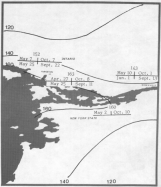
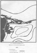
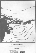
The water temperatures are monthly averages, based on eleven years of record, from a point 15 km southwest of Kingston. During the fall, the land surface loses heat more quickly than the water, resulting in mean air temperatures approximately 4ºC cooler than the mean water temperature. The mean maximum air temperatures throughout SLINP shown in Figure 2.1 are similar to the mean water temperatures. This exemplifies that the relatively warm river is keeping the air temperatures higher than it would be if the river was not present. 2.2 Frost [Top] The average date of the last spring frost, the first autumn frost and the length of the frost free period is shown on Figure 2.2.
This map shows a longer frost free period along the St. Lawrence River and near Lake Ontario than further inland. The average frost free period of 160 days on most of the islands, for example, is comparable to the 145 days at the east end of the park. 2.3 Growing Season [Top] Closely related to the length of the frost free period in agricultural decision making is the accumulation of growing degree days as an index of the amount of heat available during this period. The index is usually defined as the number of degrees of mean daily temperature above a base of 5.5ºC. Table 2.1 shows the growing degree day monthly averages for selected stations. It can be seen from the table that the growing potential during springtime within the Thousand Islands is lower than at either Ottawa or Toronto. This is the result of cooling by Lake Ontario. After July, the river becomes a source of heat, resulting in a growth potential near the Thousand Islands considerably higher than Ottawa and only slightly less than Toronto.
2.4 Water, Ice, and Air Temperatures [Top] Water temperatures start to cool in September and decrease rapidly until December. Ice begins to form among the islands in December. By February, on the average, ice extends into the northeast corner of Lake Ontario and as far as 30 km southwest of Wolfe Island. During the period from late December to late March when SLINP is ice bound, the maritime influences of the river are least pronounced.
As the ice melts in late March and early April, the water temperatures respond more slowly to the seasonal increase in solar heating than do the air temperatures over the surrounding land area. As a result, the mean daily air temperatures along the shore are higher than the water temperatures, although the daily minimum temperatures are similar in value to the water temperatures (refer to Figure 2.1). The cool waters of the river thus keep the daily shoreline maximum and mean temperatures lower than those further inland. At night, however, the air temperatures further from the river become cooler than those near the river. Mean Daily Air and Water Temperatures
2.5 Precipitation [Top] In discussing precipitation one must remember that the effects of the lake and the wider section of the St. Lawrence River change with the seasons. During late fall and winter, the open waters result in lake effect snow showers. On the other hand during the summer the cool water surfaces cool the air in the lowest layers and thereby lower the frequency of showers and thundershowers. During late fall and early winter, the surface temperatures of the water of Lake Ontario and St. Lawrence River decrease to near 0ºC. Since the air is considerably cooler than the water, these areas of open water add both heat and moisture to the air. This causes clouds to form over the lake. The general wind flow transports these clouds to adjacent land areas. These moisture-laden clouds then deposit snow in regions downwind from the Lakes. The area influenced by these lake-effect snowfalls depends on the strength and direction of the wind flow over the lake and the magnitude of the water-air temperature gradient. The St. Lawrence Valley channels the wind flow off Lake Ontario along the length of the Thousand Islands and causes lake effect snowfalls further inland along the river than in areas south of the Lakes. During the summer, the cooling of the air, produced by Lake Ontario and the St. Lawrence River, reduces the amounts of rainfall occurring within the park.
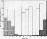
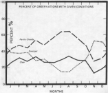
Measurable rain occurs most frequently in May, with an average of eleven days per month. The frequency of rain decreases to nine days per month from June to September. The lowest measurable rain occurs during January and February with only four and three days per month respectively. The highest frequency of thunderstorms occurs in the period of June to August. The highest frequency is 6.7 days per month reported in July. There is almost no thunderstorm activity during the winter months. 2.6 Winds [Top] Although winds from the westerly quadrants generally prevail, since the movement of the weather systems is from west to east, winds from any direction can occur. The lows and highs are much more intense and move rapidly during the colder half of year. In the summer months, strong winds are rare and are only encountered in association with thunderstorms and squall lines. Ordinarily, winds reach higher speeds over open water than over rougher land surfaces. This is due to the differences in surface friction between land and water. Consequently, winds can be expected to reach higher speeds over open water areas surrounding the Thousand Islands than over the land areas away from the river. This would be particularly evident when southwesterly winds from the open water of Lake Ontario funnel down the St. Lawrence River. On the average, winds reach their highest speed during November in the Kingston area and during February in the Cornwall area. Wind speeds from all directions average near 20 kilometres per hour with the highest value in the range 25-30 kilometres per hour from the southwest. Summer wind speeds are generally 8-10 kilometres per hour lighter than during winter. Over the park, winds average 15-18 kilometres per hour from the southwest and would occur 40 to 50% of the time. The strongest winds experienced in the region will occur with thunderstorms during the summer. 2.7 Cloudiness and Fog [Top] The monthly variation in cloud cover is summarized in Figure 2.7. This figure presents the number of hours reporting the given conditions as a percent of the total observations. The sunniest, most cloud-free period occurs during July and August. During these months, overcast skies were reported only 14% of the time whereas the frequency of partly cloudy skies was 64%.
The most frequent restriction to visibility is fog. Fog is created when the air cools to a temperature at which the moisture in the air condenses and forms small water droplets. For this reason, it is prevalent when daily temperatures are lowest. Fog also forms when relatively warm air flows over a cool surface and is itself cooled. This situation occurs near SLINP in the springtime when the air is warmer than the water bodies. During the winter months visibility is most frequently reduced by falling or blowing snow. Rain, although it does lower the visibility, does not restrict it as much as fog or snow. 2.7 Microclimate [Top] A phenomenon called microclimatic effect is an important feature in ecological terms in the Thousand Islands. Microclimate might be defined as the climate at small or specific sites. In this region, because of the highly irregular topography, variations in climate at a small scale are quite pronounced. South-facing slopes can be contrasted with north-facing slopes. The south-facing slopes receive the sun's rays at angles nearer perpendicular than north-facing slopes, and consequently are warmer. As well, south-facing slopes may receive a fuller effect of the generally prevailing south-westerly winds. As a result, south-facing slopes are drier because of increased evaporation and lower humidity relative to north-facing slopes. Slopes at shorelines have a climate somewhat different than the slopes facing the same direction but which are inland. Water temperature can influence the air temperature above it, and so can have the effect of warming or cooling, depending on the temperature of water relative to the air. Variations in vegetation cover or habitat type also vary the climate to a small degree. In a forest, the shade cast by trees prevents the soil temperature from rising to the degree seen in fields and on outcrops. As well, the humidity at the forest floor is greater relative to a nearby open area. Tall vegetation reduces wind speed, and so lowers the rate of evaporation as well. Figure 2.7 presents some comparative data. Microclimatic effects are seen quite readily in the character of the forest. Open, sun-warmed sites host plant and animal species quite different from closed, damp, shaded sites. For example, the southwest ends of islands or ridges often host pitch pine (Pinus rigida), eastern red cedar (Juniperus virginiana), blueberry (Vaccinium spp.), and juniper (Juniperus spp.) bushes, where north-facing slopes often support eastern hemlock (Tsuga canadensis), striped maple (Acer pennsylvanicum), yew (Taxus canadensis), and basswood (Tilia americana). People, too, are quick to recognize the subtle variations in climate, taking to the shade on the hot summer days, seeking the sun on cool mornings, and taking to the forest to avoid winter winds. 3. Conclusion [Top] Any discussion of the climatology of the Thousand Islands region area must recognize that the influence of Lake Ontario and the St. Lawrence River is the most important climatic control. In the spring and fall the generally ice-free lake moderates air temperatures along its shores. Frost hazard is reduced and the growing season lengthened. In the summer, the river reduces temperature extremes along its shores. Most of the summer daytime cooling can be attributed to the influence of the lake river breeze effect. The bodies of water also influence the humidity of the air and the aerial distribution of cloud and precipitation. In an average year, the Great Lakes increase the humidity of the air about 15%. In the summer the increase is about 10%, in the fall about 15%, and in the winter about 30%. In the early spring, fall, and early winter there tends to be greater cloud development over Lake Ontario. In the late spring, summer, and early fall, the effect is reversed with daytime cumulus development over the warmer land areas, but not over the cooler water. In the summer, daytime showers and thunderstorms are more likely to form over the warmer land. In the winter, before freeze up sets in, the cold air blowing off the land over the relatively warm waters of the river and lake causes the so-called "lake-effect snowstorms". Along the St. Lawrence River, the highest frequency of fog occurs during the winter months. The principal cause is the rapid cooling of moist air by the cold surface. Also, radiation fog is frequent during clear nights in the spring and fall. These fogs are of a local nature, their frequency depending greatly on the topography. References [Top] Brown, D.M., G.A. McKay and L.J. Chapman, 1973. The Climate of Southern Ontario. Climatological Studies No. 5, Canada Department of Transport, Meteorological Branch. 50 pp. Crowe, R.B., G.A. McKay, and W.M. Baker, 1973. The Tourist and Outdoor Recreation Climate of Ontario. Vol. 1 to 4. Publications in Applied Meteorology, Rec. 1-73, Atmospheric Environment Service, Department of Environment, Toronto. Greggs, R.G. and W.A. Gorman. Geology of the Thousand Islands. Dept. of Geological Sciences, Queen's University Kingston, Ontario. 80 pp. Irbe, J.G., 1972. Aerial Surveys of Great Lakes Water Temperatures, April 1968 to March 1970. A.C.S. Climatological Studies No. 19, Toronto. 57 pp. Juisto, J.E., Kaplan, M.L., 1973. Snowfall from Lake Effect Storms. Monthly Weather Review Vol. 100, No. 1, pg. 62-66. Nelson, J.G., M.J. Chambers, 1970. Process and Method in Canadian Geography Weather and Climate. Methuen Publications. Pack, Dr. A. Boyd, 1973. Climate of New York. Climatography of the United States No. 60-30, U.S. Department of Commerce. 29 pp. Petterssen, 1958. Introduction to Meteorology, McGraw-Hill Book Company, Second Edition. Phillips, D.W. and J.A.W. McCulloch, 1972. The Climate of the Great Lakes Basin. Climatological Studies Number 20, Toronto. 40 pp. Richards, T.L., G.J. Irbe, and D.G. Massey, 1969. Aerial Surveys of Great Lakes Water Temperatures, April 1966 to March 1968. Climatological Studies Number 14, Toronto. 55 pp. Richards, T.L. and D.W. Phillips, 1970. Synthesized Winds and Wave Heights for the Great Lakes. Climatological Studies Number 17, Toronto. 53 pp. |
||||||||||||||||||||||||||||||||||||||||||||||||||||||||||||||||||||||||||||||||||||
|
|
||||||||||||||||||||||||||||||||||||||||||||||||||||||||||||||||||||||||||||||||||||