 Plants of the Thousand Islands Plants of the Thousand IslandsOriginal Manuscript |
||||||||||||||||||||||||||||||||||||||||||||||||||||||||||||||||||||||||||||||||||||||||||||||||||||||||||||||||||||||||||||||||||||||||||||||||
|
See also: A Natural Heritage Review of the 1000 Islands Ecosystem Species Checklists
Table of Contents Distribution maps
Abstract [Top] An attempt is made to outline the history of the vegetation of the St. Lawrence Islands National Park region since the Wisconsin glaciation. Representative distribution patterns of various plant species are given. Comments are presented on the occurrence of some of the rarer and more interesting species within the borders of the park. There are two appendices: an updated listing of the floras of the individual islands, entitled "The vascular plants of the Thousand Islands National Park region", and "a forest type and ecological zone report of the St. Lawrence Islands National Park". Introduction [Top] A botanical survey was carried out in St. Lawrence Islands National Park and adjacent areas during the summer of 1975, by W.J. Cody (Research Scientist) and D. Munro (Summer Student) of the Biosystematics Research Institute. Approximately 1,500 specimens were gathered from the various islands and adjacent mainland. These are deposited in the Herbarium of the Canada Department of Agriculture at Ottawa, and a representative set has been mounted and given to St. Lawrence Islands National Park for preservation in the park herbarium. Observations were made on plant distribution, the various habitats on the islands, and particularly the present forest cover. The herbaria of the Canada Department of Agriculture (DAO), Queen's University (QK) and St. Lawrence Islands National Park were consulted, and numerous literature references related to the park were investigated. The known ranges of many species were examined to determine their relationships, one to another. Species which were of special interest because of their rarity in the park, or which possessed a peculiar or interesting distribution, were noted. The park lies in what Rowe (1972) has described as the Middle Ottawa Section of the Great Lakes - St. Lawrence Forest Region. This zone is characterized by sugar maple (Acer saccharum), American beech (Fagus grandifolia), yellow birch (Betula alleghaniensis), red maple (Acer rubrum), eastern hemlock (Tsuga canadensis), eastern white pine (Pinus strobus) and red pine (Pinus resinosa) in the uplands with varying amounts of white birch (Betula papyrifera), red oak (Quercus rubra), American basswood (Tilia americana), white spruce (Picea glauca), balsam fir (Abies balsamea) and trembling aspen (Populus tremuloides). Throughout this zone are hardwood and mixedwood swampy areas in which eastern white cedar (Thuja occidentalis), tamarack (Larix laricina), black spruce (Picea mariana), black ash (Fraxinus nigra), red maple (Acer rubrum) and American white elm (Ulmus americana) are found. In this zone, there are some species which are distinctly southern in range and not characteristic of it. Among these are butternut (Juglans cinerea), bitternut hickory (Carya cordiformis), bur oak (Quercus macrocarpa), white ash (Fraxinus americana) and black cherry (Prunus serotina). Adjacent to the St. Lawrence River, there are in addition to most of the broad ranging trees and the southern elements mentioned above, several tree species which do not extend very far north of the river, although they are quite common there and sometimes form large stands. Among these are shagbark hickory (Carya ovata), pitch pine (Pinus rigida), eastern red cedar (Juniperus virginiana) and swamp white oak (Quercus bicolor). This part might be better treated as the northern extension of a more southern forest type, and is thus of considerable interest. Indeed, it is the only place in Canada, with the exception of a very small stand in the southern part of the Eastern Townships of Quebec, where Pinus rigida is known to occur. A part of this narrow strip could well have been designated for preservation under the IBP/CT program. The age of the trees on various islands is not great and by and large, the individual stands appear to be even-aged. Indeed on most islands, with the exception of Thwartway, there is little or no sign of stumps and fallen and rotting trees. This would indicate that most of the islands had been cleared of trees, either by felling for firewood, or burning to clear the land for agricultural purposes (particularly grazing) or even accidental burning from camp fires or lightening strikes. Exceptional, and of considerable age, are a few huge trees representing several species; e.g. Pinus strobus and Quercus borealis found along the right-of-way east of the Grenadier Island campground. In a forest inventory survey (MacDonald, 1973) the following maximum ages and heights were given:
These figures are corroborated by the following observations made during the 1975 survey:
MacDonald (loc. cit.) too, indicated that there were signs of fire having swept many of the islands about the turn of the century, that certain pioneer species dominated some islands and that better sites could be picked out because the forest tended to recover in these situations first, and thus these trees were older and larger. In the boreal forest, jack pine (Pinus banksiana) is a pioneer species of sandy and rocky areas following fires. Pitch pine (P. rigida) is undoubtedly a similar pioneer species. The mature trees which dominate certain sectors of some islands, to the eye, often appear rather sickly, and there is certainly little regeneration of the species. Indeed, if there is regeneration of tree species it is some broad-leaved tree. It is possible that fire may be necessary for pitch pine to survive in sites other than rocky promontories where competition from other species is not a factor for survival. The various disturbances which have taken place on the islands have undoubtedly affected shrub and herbaceous species as well, although this fact is not as readily discernable as with tree species. Thus, compared to mainland regions, the total flora of the park and of the individual islands is relatively low. For instance, the total flora (introduced and native species) in the Ottawa District (within a radius of 30 miles / 48 km of Ottawa) is about 1,300 species (Gillett, 1958) and that of the Kingston region, which includes St. Lawrence Islands National Park, is over 1,600 species (Beschel et al, 1970). The total flora for the park is 830 species representing 100 families of flowering plants. The floras of the various islands as known in 1975 and the acreages of the islands are as follows:
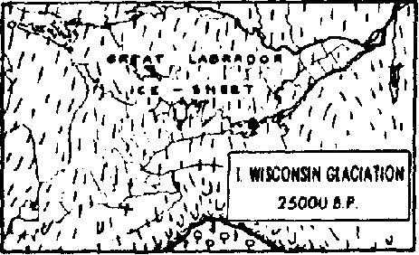
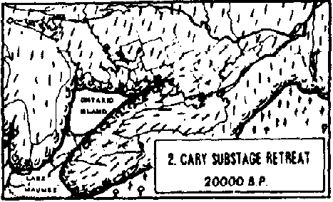
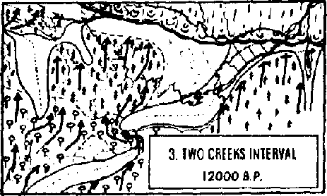
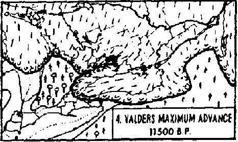
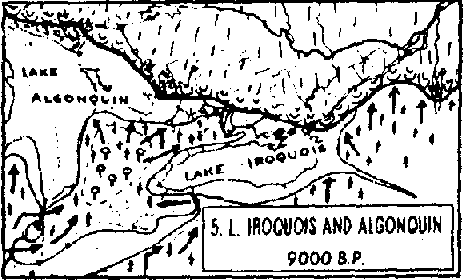
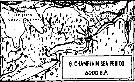
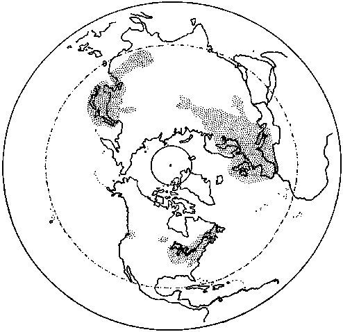
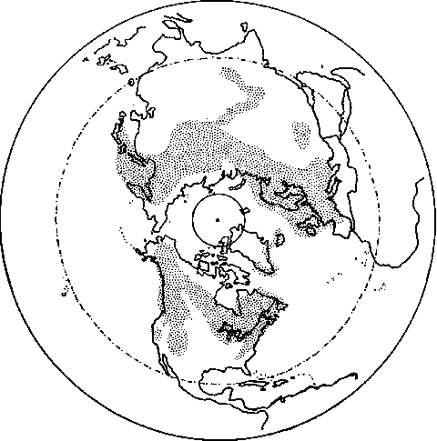
Discussion [Top] Long before the disturbances which have taken place since the coming of the white man, the catastrophe of glaciation, which covered most of Canada with a great layer of ice, took place. A map (Anon., 1969) showing glacial retreat of Wisconsin and recent ice in North America indicates the maximum extension of glacial ice southward into New York State was 18,000-17,000 years BP. This was in the vicinity of the present city of New York. Through successive retreats, the southern boundary of this permanent ice lay just south of that part of the St. Lawrence River which concerns us by about 12,500 years BP, and north of the Ottawa River by about 11,800 years BP. Prior to the availability of this map, Dore et al (1959) had postulated on the revegetation of southern Ontario following the retreat of the glacier:
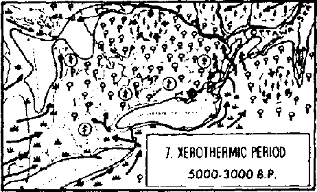
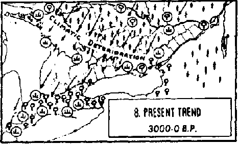
Part of the trends in vegetation cover following the retreat of the glacier can be discerned from fossil pollen studies of borings in peat bogs. There are, however, because of the nature of the islands, no peat bogs on any of the islands in the park. Such data must, therefore, be extrapolated from work done in areas nearby. Terasmae (1968), on the basis of such pollen studies, stated:
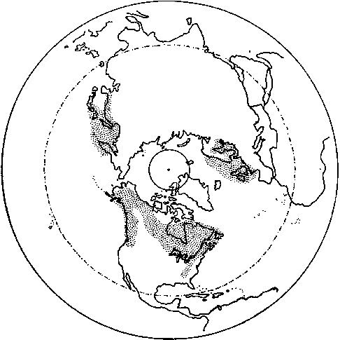
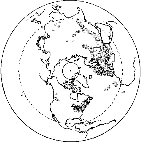
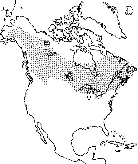
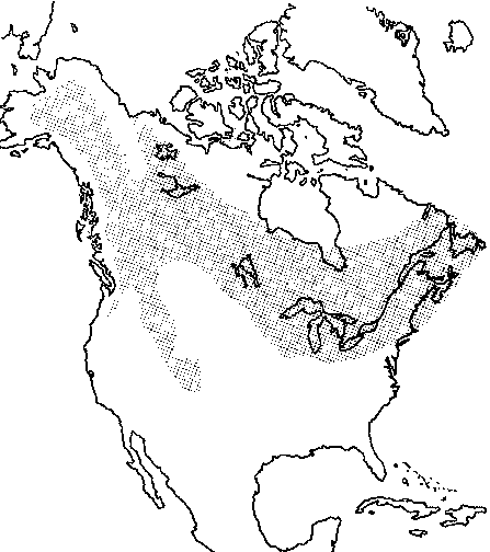
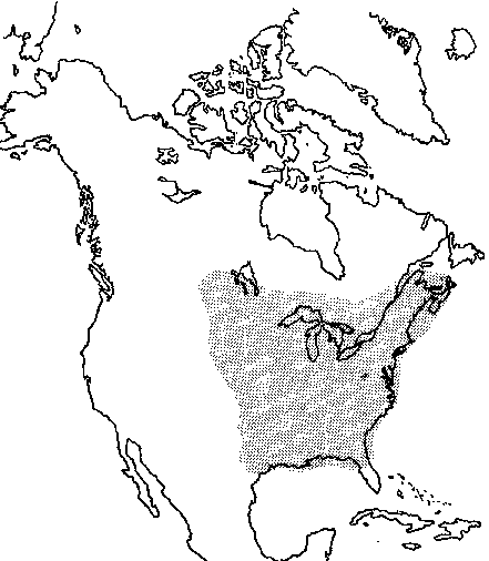
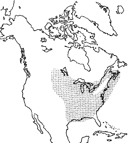
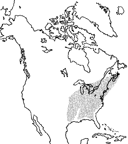
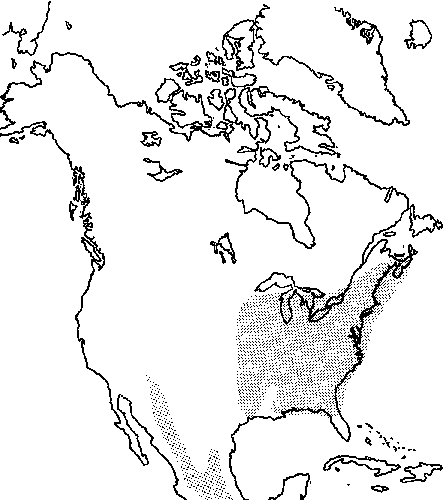
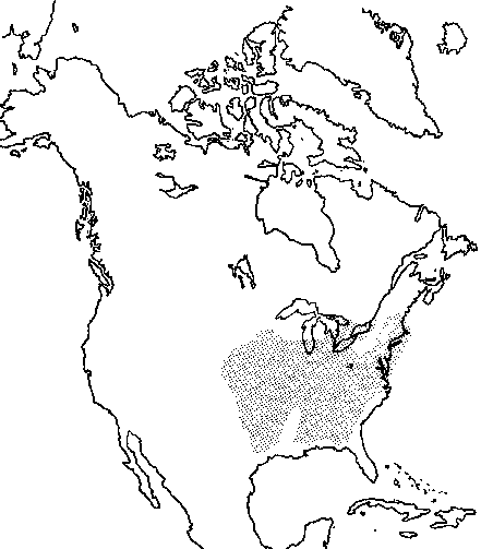
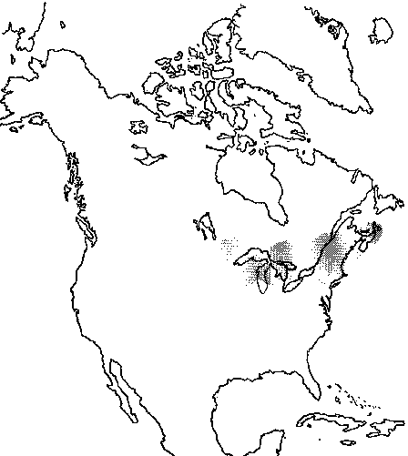
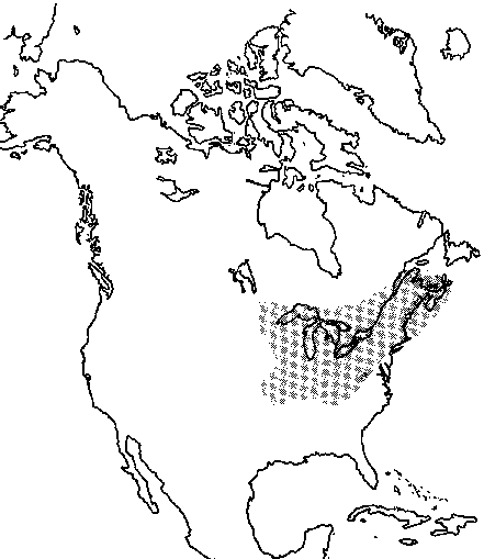
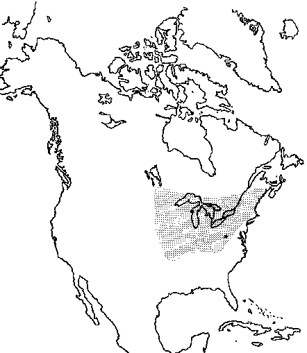
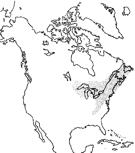
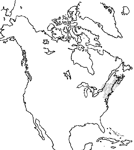
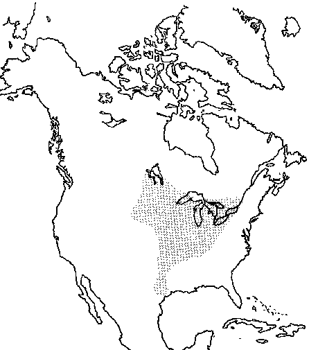
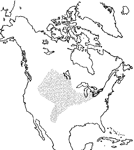
The species composition of the St. Lawrence region has gone through a series of stages which were dominated by different species as demonstrated in the Harrowsmith diagram, but only fragments can be deciphered. That the species are still moving can be discerned, not only from the weedy introduced species from the Old World, but from native species, (eastern red cedar (Juniperus virginiana) as an example), is invading old fields in the area north of eastern Lake Ontario and the upper St. Lawrence River; the old field or grey birch (Betula populifolia) has been marching westward into eastern Ontario from Quebec; the pitch pine (Pinus rigida) which now forms large mature stands on some of the islands, and on ridges north of the river, is not reproducing well, and may indeed need a fire to give it new life, if indeed the present climate will permit such regeneration. The factors of temperature, moisture, wind, fire, substrate, and even native peoples have all played their part in the movement of the various species which now make up the flora of the region. Dr. John McNeill has prepared the following statistical study of relationships between the number of species on the various islands and areas of the islands. There are two well-known linear relationships between the size of a particular area and the number of species occurring within it. In any one association, if the number of plant species is counted in a series of samples (e.g. quadrats), then (except for very small areas) the number of species found increases linearly as the logarithm of the area sampled (usually expressed as the logarithm of the number of quadrats). The slope of the straight line plot of number of species (S) against log area is a measure of the diversity of the particular association. When natural logarithms are used, the equation of the straight line is usually expressed as S = aloge Q+ D. Here a is the Index of Diversity. (Incidentally D is expressible as a (log N - log a - log Q), where N is the number of individual plants in a sample Q sq. metres in size. Details of these relationships are discussed by Williams (1964, ch. 4.) In large areas with a diversity of associations and environments, a different relationship holds. Here the number of species (S) of any one group of organisms is related to the area (A) according to the equation S = CAz, which can be expressed as log S = z log A + log C. Thus there is a linear relationship between the logarithm of the number of species and the logarithm of the area. (For details see Williams, 1964, ch. 5 and MacArthur and Wilson, 1967, ch. 2). This relationship has been applied extensively to island biogeography and the values of z determined empirically are reasonably consistent with the theoretical value of 0.27, calculated under the assumption that the frequency curve of species containing various numbers of individuals is lognormal (Preston, 1962). Where the samples are of increasing size form the same island or from a continental area, values of z are usually much lower: 0.12-0.17 as against the common range of 0.20-0.34. C, like D above, is a function of population density and varies widely with the type of organisms involved and the biogeographic region of the world. Although the St. Lawrence Islands all comprise more than one ecological association, they are sufficiently small and topographically uniform for it to be worth applying the first model to them, particularly if Grenadier and the Mallorytown mainland are excluded. The numbers of species recorded from each island (up to 1975), can be plotted against the natural logarithm of the area of each island and the appropriate regression line fitted (y = 109.10 + 14.8.62x). From this it appears that Gordon and Thwartway do not fit the linear relationship postulated as well as do the others. (Both are beyond one standard deviation, 34.57, of the regression line). This suggests that the assumption of ecological homogeneity of all the islands is not valid for these two. In fact, species-rich Gordon is the only island with a sandstone substrate, and Thwartway, with relatively few species, has suffered very much less disturbance than any of the others. When Grenadier and Mallorytown are excluded, the regression line is less steep (y = 132.00 + 117.85x), bringing Thwartway within one standard deviation (27.11) of it, but excluding Gordon rather more significantly. If the analysis is further restricted to the 15 smaller granitic islands (i.e. excluding Gordon also), the position and slope of the regression line (y = 129.40 + 116.5x) are little changed but provide a better fit, with one standard deviation equal to 23.9. The Index of Diversity is 64.5 when all 18 areas are considered, reducing to 51.2 when Grenadier and Mallorytown are excluded and to 50.6 if Gordon is also omitted. These figures can be compared with those calculated for single associations in arid land in New South Wales ranging from 4.8 to 6.2 and in alpine valleys in Switzerland from 3.4 to 12.1 (see Williams, 1964). The much higher values in the St. Lawrence Islands are partly a reflection of their greater species diversity over arid land in Australia and some of the Swiss habitats (the higher alpine ones), and are partly due to the islands comprising several associations, for which this model is not strictly valid. Applying the second model, the regression line is a somewhat poorer fit (accounting for 78.5% as against 82.1% of the spread). As is to be expected, Grenadier, the largest and most diverse island, fits more readily than in the first model. Moreover, in addition to Gordon again appearing as unusually species rich, Mermaid is identified as being marked species poor. This is possibly simply a reflection of its absolute size being so small, that the number of possible habitats is restricted to a greater extent than would be predicted by its relative size (i.e. this model is not applicable to such small areas as Mermaid). The regression line can be expressed as S = 141.7 A0.24 . This value of z = 0.24, is interestingly close to the theoretical value of 0.27. Mallorytown, as part of the mainland, would be expected in theory to have rather more species than predicted by the model. (This is because of the likely occurrence within the area of species that are only marginally adapted, but which are maintained because of areas just outside the boundary to which they are well adapted; in an island situation such species would be less likely to survive). In fact Mallorytown falls below the regression line, suggesting that the park area there is either much more uniform than islands of comparative size would be, or else is underexplored. Indeed, the latter is undoubtedly the case because there are, for instance, few shoreline species such as Typha and Sparganium recorded from there, and no species of pondweeds, although the dock area abounds with such plants, often to the annoyance of boat operators. The relatively small number of species in the park is, however, not only because of the small size of the area, but is because of the absence of certain habitats, and the shallow soils on the Precambrian rocks which tend to dry out where they are exposed. There are, for example, no bogs, no limestone exposures, although Gordon Island is a level sandstone and there is some limestone on Cedar Island, there are no streams, no "ferny glens" and few swampy areas. Of the 809 species of vascular plants for which there are either reports or specimens from the park islands and mainland property, 176 are introduced. These introduced species are mainly plants which have come from the Old World with the white man and are essentially weeds of agricultural land. Examples of these are the dandelion (Taraxacum officinale), plantain (Plantago major), sheppard's purse (Capsella bursa-pastoris) and mullen (Verbascum thapsus). Purple loosestrife (Lythrum salicaria) is, however, a very showy, weedy species of Old World origin which has invaded wet land, shorelines and swamps (Map 1), the flowering rush (Butomus umbellatus), another European invader and very showy species, is found in shallow water along shorelines and a pondweed (Potamogeton crispus) inhabits the water of protected bays together with native species of pondweed. A few introduced species are those which were cultivated as ornamentals or crop plants which have persisted and sometimes spread, primarily by their root systems. Lilac (Syringa vulgaris), day lily (Hemerocallis fulva) and clamy locust (Robinia viscosa) fall in this category. Of the species which are native to the region, the largest proportion are eastern North American in general range, a few are boreal transcontinental, a few are mid-western and a small number are circumpolar in distribution. To demonstrate some of the distribution patterns of species which make the flora of St. Lawrence Islands National Park, some examples of the various types, mainly readily recognizable trees. The North American maps (Maps 5-21) were adapted from Little (1971) and the circumpolar maps (Maps 1-4) from Hulten (1971). Common juniper (Juniperus communis) is an almost completely circumpolar species which is absent in eastern Siberia and extreme western Alaska. In North America it is boreal, but also extends southward through the mountains of western United States. Several more or less intergrading varieties are involved (Map 2). Sweet gale (Myrica gale) is circumpolar, but there is a large gap in distribution between northern Europe and the eastern Asiatic population. In North America it is somewhat similar in distribution to Juniperus communis, but does not extend as far south in the Western mountains (Map 3). Herb-robert (Geranium robertianum), again is circumpolar in distribution. It has an almost solid range in Europe, scattered stands in Asia and in North America is divided into an eastern population which extends from Newfoundland to Lake Michigan, and several west coast populations (Map 4). Perhaps the best example of a North American boreal forest tree is white spruce (Picea glauca) (Map 5). It is found from Newfoundland to western Alaska, but with the exception of a gap in the Yukon Territory, is similar to that of balsam poplar (Populus balsamifera), but it does not extend as far into British Columbia although in the east it extends farther south to encompass most of the Great Lakes region (Map 6). Trembling aspen (Populus tremuloides), another boreal species, has a northern limit of distribution very similar to that of Populus balsamifera, but in the east extends southward into the northern Mississippi River drainage, and in the west is, with the exception of the coastal area, found throughout British Columbia and then south into the United States to northern New Mexico (Map 7). As mentioned above, the largest percentage of the species which make up the flora of St. Lawrence Islands National Park are centred in the east. The American elm (Ulmus americana) is found over perhaps the largest area of any of the species of this group. It is absent in Newfoundland, but extends westward to Saskatchewan where it is very reduced in size and far different in shape from our magnificent umbrella-shaped tree. In the United States it extends into half of Texas, along the Gulf Coast, and is only lacking in the southern half of Florida (Map 8). Red ash (Fraxinus pennsylvanica) is very similar to Ulmus americana in distribution, but does not occur as far north in northern Ontario, and there is a blank area in the Appalachian Region (Map 9). White ash (Fraxinus americana) has a range which lies completely within that of Fraxinus pennsylvanica, but is considerably smaller. In Canada, it is absent in the Gaspé and west of Sault Ste. Marie, and is also absent from the coastal parts of the Carolinas, Georgia and the Gulf states (Map 10). Black cherry (Prunus serotina) is quite similar in distribution in the northern parts to Fraxinus americana, although it is found on the coastal plain of the Carolinas, Georgia and the Gulf states. There is in addition, however, a separate population which is found throughout a large part of Mexico (Map 11). The southern distribution of eastern red cedar (Juniperus virginiana) is close to that of Fraxinus americana, but in Canada is restricted to southern Ontario and a disjunct population in Quebec along the north shore of the Ottawa River near Ottawa. As mentioned previously, this species is invading old fields in the area north of eastern Lake Ontario and the upper St. Lawrence River (Map 12). Red pine (Pinus resinosa) forms a relatively narrow band, which straddles the Great Lakes (with the exception of Lake Erie) and extends in the east to Nova Scotia, and in the west to the Manitoba border (Map 13). Sugar maple (Acer saccharum) is rather similar to Pinus resinosa in its northern limits, bellies down into the United States as far south as Tennessee (Map 14). Eastern hemlock (Tsuga canadensis) extends in range from Nova Scotia westward across southern Quebec to Sault Ste. Marie and Wisconsin in one broad finger and south ward in another broad finger through the Appalachian Region, south to eastern Tennessee and western North Carolina (Map 15). Basswood (Tilia americana) is found in Canada from southern New Brunswick across southern Quebec and the southern half of Ontario, is absent on the north shore of Lake Superior, and is found again in southern Thunder Bay District, southern Rainy River District and southeastern Manitoba. Southward it is found to near the junction of the Ohio and Mississippi rivers (Map 16). Eastern white pine (Pinus strobus), for which this country was noted in early days, is found from Newfoundland across Quebec and Ontario, north of Lake Superior to the near Manitoba border. Its range includes all the Great Lakes and extends southward through the Appalachians to eastern Tennessee and North Carolina (Map 17). Old field or grey birch (Betula populifolia) is found in Nova Scotia, New Brunswick, the southern part of Quebec, excluding the Gaspé, is expanding its range into eastern Ontario and extends southward into the United States, Pennsylvania and New Jersey (Map 18). A few species have a more central North American distribution: Bur oak (Quercus macrocarpa) is found only as far east as the Ottawa River Valley and extreme southwestern Quebec, but is found throughout southern Ontario, is absent on the north shore of Lake Superior, but is found in southern Thunder Bay District, southern Rainy River District and the southern third of Manitoba. Southward it extends over much of the Mississippi River drainage with a spur reaching almost to the Gulf in Texas (Map 19). Rock or cork elm (Ulmus thomasii) is found across southern Ontario to the vicinity of Montreal, but does not extend far south of Lake Ontario and Lake Erie. Westward it extends south of Lake Michigan across Minnesota and Iowa to near the Dakota border (Map 20). Peach leaved willow (Salix amygdaloides) reaches its northern limit in central Saskatchewan, is found in the southern third of Manitoba and southwestern Alberta, and extends south through the United States to much of New Mexico, and eastwards in a sweep through the middle of Lake Michigan, across southern Ontario and including Lakes Erie and Ontario to the vicinity of the Thousand Islands National Park (Map 21). There are no species which are endemic to St. Lawrence Islands National Park or its immediate vicinity. There are, however, numerous species which are of particular interest, either because of their rarity in the area, limit of range, direction of invasion of eastern Ontario, general distribution or peculiar habitat. Some of these are recorded below. There are indeed relatively few different habitats in the park, a fact which limits the number of species in the flora. Thus for instance, because there are no bogs, there are but few orchids, and relatively few sedges and ericaceous plants. Also, because there are few "rich" woods with deep ravines, there is a paucity of ferns and some other deep woodland species. Lycopodium complanatum - the only island from which this species is known is Grenadier. It does, however, carpet the floor of a mixed deciduous woods which lies between the golf course and the south shore of the island. It is circumpoIar in overall distribution. Equisetum hyemale - this is the scouring rush that early settlers used to clean their pots because of the fine silica deposits on the surface of the stems. It has completely taken over the esker slope in an old field west of the camp area on Grenadier Island. It too is circumpolar in overall distribution. Botrychium spp. - the species of grape ferns, with the exception perhaps of B. virginianum, which is a woodland species, are rare in most parts of Canada. These are, however, frequently overlooked. Osmunda spp. - these three species are rare on the islands only because low wet habitat such as is found on part of Grenadier Island is not universal. All species are rather widely distributed in Eastern North America. Adiantum pedatum - the maidenhair fern is usually found in rich, moist, rocky woods and is, therefore, rare. It is widely distributed. Asplenium platyneuron - the ebony spleenwort has a very scattered distribution across southern Ontario, and its occurrence on the mainland property is, therefore, of interest. It has only recently been discovered in the Ottawa area. Southward in the eastern United States, it is more frequently found. Asplenium trichomanes - the maidenhair spleenwort is found in shaded usually calcareous, rocky crevices and thus has a rather spotty distribution. The only island site was on Georgina, where it was very rare and although the rock is precambrian, there may be some traces of crystalline limestone in a crevice similar to that in Gatineau Park. It is also known from the mainland at Mallorytown Landing. Camptosorus rhizophyllus - the walking fern, found on a sandstone rock by Jones Creek, is not otherwise known from the region. It too requires shade, usually calcareous, situations and thus is of very spotty occurrence in southern Ontario and southern Quebec. Pellaea glabella - the smooth cliff-brake is also known only from Jones Creek where it occurs in dry crevices of the sandstone face. It too is very rare in Canada, because of its restrictive habitat requirements. Picea glauca - there are a few young white spruce to about 6 m. in height at the east end of Grenadier Island. Because there are no mature trees here, we wondered if perhaps these trees had been planted, but they are of course within the natural range of the species, and a specimen has been collected at Landon Bay (Map 5). Pinus rigida - the pitch pine is an important and most interesting nature in the park where it forms almost pure stands on some island headlands. The westernmost island on which it is found is McDonald, where there is one mature tree and one small seedling. On the mainland it is on the rocky ridges north of the headquarters area. Vander Kloet (1973) has described the biology of this species. Najadaceae - although the various species of Potamogeton and Najas flexilis are apparently rare because few collections and observations have been made, the waterweeds are in some bays quite common, and more attention should be paid to them and their distribution in the future. Hydrocharis morsus-ranae - the European frog-bit is an introduction from the Old World in the Ottawa, Rideau and upper St. Lawrence Rivers, where it occurs in shallow quiet waters and is frequently stranded as water levels drop. It can clog some waterways and for this reason its presence in the park area should be monitored. Andropogon gerardii and A. scoparius - the first is a very tall grass which has been found in our area in mostly sandy situations along shores, but is not common here although much more so southward and westward. It was formerly known along the Ottawa River, but is now apparently no longer there. The second is rarer in our area, having only been recorded from Stovin Island. It is a characteristic plant of prairie grassland which occurs in the Ottawa District along the Ottawa and Gatineau Rivers on shores and sandy blow-outs. Bromus tectorum - this small annual brome grass which is introduced on this continent from the Old World, is a serious weed on some roadsides and waste areas. In the park it is only known from near the dock on Adelaide Island. Efforts should be made to eradicate it if at all possible. Panicum latifolium - the broad-leaved panic grass is rare in the park region and of very spotty occurrence in eastern Ontario and southwestern Quebec where it is primarily an open woodland species. It is similarly rare in the Ottawa District but is fairly common in the extreme southern parts of Ontario, particularly in sandy open woodland. It is found south to North Carolina and west to eastern Kansas. Spartina pectinata - in the Ottawa District the freshwater cord grass is almost entirely restricted to the shores of the Ottawa and Gatineau Rivers and Dore (1959) postulates that it got into the Ottava drainage from the west via Lake Nipissing. In the park it is known from Adelaide and Stovin Islands. Trisetum spicatum - this is a species which though a series of subspecies and varieties, many of which are arctic and alpine, is circumpolar in total range. It is rare in the park where it is about its southern limit. Zizania aquatica - the seed of the wild rice plant was and still is harvested by the Indians for food in some parts of Canada and the United States. It is found in shallow water along shorelines of streams and in quiet bays. It is rare in the park region, but easily recognized by its tall stature, spreading panicle of male flowers which are below the spike-like female flowers. Carex spp. - species of sedges tend not to be collected, partly because many are difficult to identify, thus many may be more frequent than the check sheet would indicate. Bog species of course would not be found on the islands. Calla palustris - wild calla is a plant usually found in quagmires, pond-margins and wet bogs. It is circumpolar in distribution, but in the park is known only from the wet black ash woods on Grenadier Island. Peltandra virginica - this is a rare species in the extreme southern parts of Ontario and Quebec where it is found along wet river shores. Southward its range extends to Florida and Texas. Its occurrence in the Gananoque River Valley has been discussed by Dore (1966), who considers it to be introduced there. There is also a specimen from Wolfe Island in the Queens University herbarium. Zosterella (Heteranthera) dubia - water star-grass may be mistaken for a narrow-leaved Potamogeton, but it can be readily identified by its yellow flowers when they are present. It is found from Florida and Texas north through the United States to southwestern Quebec and southern Ontario and may be found to be more common as botanical surveys progress. Trillium grandiflorum - the floral emblem of Ontario is not a common species in the park. It does, however, form extensive stands in the rich woodland on Mulcaster Island. It and the red trillium should be protected wherever found. Iris pseudacorus - the yellow iris occasionally forms large clumps in swampy places and along shorelines where its flowers make bright yellow spots in otherwise drab surroundings. It was formerly cultivated, but its place in horticulture has been taken over by the many more showy cultivars of I. germanica. Cody (1961) discussed the distribution of this iris in Canada. Orchidaceae - as mentioned above, this family is not well represented in the park, primarily because of the lack of suitable habitats. They should be protected wherever found. It is interesting that the one introduced species, Epipactis helleborine has been observed on all of the park islands, thus indicating that water is no barrier to its spread. Salix amygdaloides - the peach leaved willow is a species of extensive western distribution which reaches its eastern limit in the vicinity of the Thousand Islands (Map 21). Salix fragilis - these often huge willow trees which are found along the shoreline of many of the islands have probably been spread by the rooting of branches which have broken away from other trees somewhere upstream, and may indeed be the result of a single introduction in the early days of settlement. Salix serissima - the autumn willow, which is known from Adelaide and Stovin Islands, is undoubtedly not common in the park because of the lack of suitable habitats. It is usually found in calcareous marshes and bogs and is widespread from Newfoundland to southern Mackenzie District. Carya cordiformis - the Canadian distribution of the bitternut hickory according to the map in Little (1971) is divided into three zones, extreme southern Ontario, east to about Toronto, Prince Edward County and the county north of there for a few miles, and the extreme eastern part of Ontario and adjacent Quebec. It would appear to have entered Canada from the south in three separate routes. Carya ovata - shagbark hickory similarly is found in the extreme southern Ontario east to about Toronto, is absent between there and approximately Belleville where it would appear to have entered the St. Lawrence River Valley close to the east end of Lake Ontario and then spread eastward to southwestern Quebec. It is rare in the Ottawa District from whence we have only one collection from near Deschenes where there were about 60 trees in 1952, but adjacent to the St. Lawrence River and on some of the islands it forms fine stands. It is a very distinctive tree with shaggy bark from which it derives its common name. Betula populifolia - the fast running water of the St. Lawrence River has apparently been no barrier to the spread of the old field birch from the east (Map 18). Corylus americana - the American hazelnut is apparently a rare shrub in Ontario. It is found adjacent to the St. Lawrence River and extends as far downstream as Lake St. Francis in extreme southwestern Quebec, in the valley of the Trent River and near Brighton. It is in the extreme southwestern part of Ontario and then again in Rainy River District and adjacent Manitoba. Thus it too would appear to have entered Ontario from the south by three different routes. It is possible that the Indians transported this shrub to at least some of the sites where it has been found because these sites occasionally coincide with Indian habitations. Quercus bicolor - the map in Little (1971) for the swamp white oak shows the species in southern Ontario south of a line from southern Lake Huron to near Hamilton an isolated stand in the vicinity of Toronto, another isolated stand about the confluence of the Ottawa and St. Lawrence Rivers, and stands just south of the St. Lawrence River in northern New York. It has recently been identified on Grenadier and Squaw Islands in the park where it is thus of considerable interest as it is near its northern limit of range here. Parietaria pensylvanica - pellitory is found across the United States from Florida to California and ranges north into southern prairie provinces and British Columbia in the west and southern Ontario and southwestern Quebec in the east where it is quite local in occurrence. In our area it is only known from shaded sandstone ledges near Jones Creek and on Wolfe Island. Asarum canadense - the wild ginger was used by the early settlers as a substitute for the imported spice. It grows in rich woods but is not common in the park where it has only been reported from Grenadier Island and the mainland at Mallorytown Landing. There are, in addition, other known mainland sites near Gananoque and Mt. Fitzsimmons. Wild Ginger occurs as far north in Ontario as the Kenogami River in latitude 50(I:(BN and is also known in Thunder Bay District. Chenopodium foggii - this is a species of lamb's quarters which has only recently been described. It is very rare in the region being known only from Grenadier and Smoke Islands and near Gananoque Lake. It might be confused with the introduced C. album, but it is a more delicate plant with narrower leaves. Chenopodium berlandieri - this is a native species of lamb's quarters which in the park is known only from Beaurivage Island. It is the common lamb's quarters in the Prairie Provinces, but is quite rare in the east. It can be readily differentiated from the weedy C. album by its reticulate seed coat. Phytolacca americana - the dark fruit of pokeweed was used by the Indians as a dye, and it is possible that the species might have been transported by them. The root is poisonous and some other parts of the plant may also be, but the boiled young sprouts have been used as greens in some areas. It is frequent in southwestern Ontario, also known about Georgian Bay, and apparently rare along the upper St. Lawrence River and in southwestern Quebec. Anemonella thalictroides - the rue anemone would appear to have entered Ontario from the south probably from three directions: across the Detroit River, across the Niagara River, and across the upper St. Lawrence River. The species is found in the Carolinian zone of southern Ontario is absent north of Lake Ontario east of Toronto, and is found again in the woodland at Mallorytown Landing. Its distribution has been discussed by Soper et al (1963). The nearest known site in northern New York state to the Mallorytown Landing occurrence is about 85 miles (136 km) to the south. Hamamelis virginiana - witch-hazel is a frequent shrub or small tree in the Carolinian zone of southern Ontario to a few miles east of Toronto. It is then rare along the north shore of Lake Ontario until it appears in some concentration in the Thousand Islands region of the upper St. Lawrence River. There are a few collections downstream from here until southwestern Quebec. Populations in the Ottawa area may have migrated there via the Ottawa River valley from the Montreal area rather than overland from the south. Desmodium nudiflorum - this is a rather rare species in southern Ontario and southwestern Quebec which appears to have entered Canada around both ends of Lake Ontario, and which is apparently absent north of the lake. Desmodium paniculatum - the collection from Wells Island at QK is the only specimen I have seen in eastern Ontario. Other Ontario collections at Ottawa are all essentially from the Carolinian zone. The other species of Desmodium found in the park, D. canadense and D. alutinosum, although rare in the park area are of broader distribution. Lespedeza spp. - the distributions of the Ontario species of bush-clover were plotted by Soper (1962). It would appear that all three species, L. capitata, L. hirta and L. intermedia are in the Carolinian Zone of southern Ontario, but have also entered eastern Ontario around the east end of Lake Ontario. L.capitata has reached the Ottawa area and as far west as Northumberland Co.; L. hirta is found along the upper St. Lawrence River and in southern Hastings Co.; and L. intermedia is only in the St. Lawrence River valley in the vicinity of the Thousand Islands. Geranium carolinianum - Ontario specimens of this species of geranium in the Department of Agriculture herbarium at Ottawa are all from the extreme southwest part of the province. The collection in the Queens University herbarium from Thwartway Island is thus of considerable interest, and would indicate that the species has entered Ontario from two different directions. Rhus copallina - the dwarf or shining sumach is another of those species which appears to have penetrated into Ontario in the Carolinian Zone and again around the east end of Lake Ontario. In eastern Ontario it has reached as far inland as Kaladar in central Lennox and Addington county. It is not known from the islands of the park from our collecting, but there is a specimen in the herbarium of the Montreal Botanic Garden from the Thousand Islands and we did collect it on the mainland park property. Staphylea trifolia - the bladdernut is a species of very sporadic occurrence in our area. At least some of the sites where it has been found in eastern Ontario are aboriginal habitation sites, so there may be some correlation. The dried fruit makes a quite effective rattle, such as might have been used by a medicine man. Helianthemum canadense - this species has what appears to be an interesting distribution in Ontario. It is in the Carolinian Zone, in the St. Lawrence River Valley in the Thousand Islands area, near Sault Ste. Marie, and in the upper Ottawa near Petawawa and Calumet Island. The Ottawa River populations possibly came from the west at a time when various other species were migrating from that direction, while the Thousand Islands population probably came from the south around the east end of Lake Ontario. Taenidia integerrima - in eastern Ontario the yellow pimpernel is known only along the St. Lawrence River. W.G. Dore believes that the distribution of this species in this area is related to the movements of the native people. Vaccinium stamineum - the record of the occurrence of deerberry in the Thousand Islands was first published by John Macoun (1881) who also noted its presence in the Niagara River region. Vander Kloet (1972) reported the rediscovery of this shrub on Wellesley Island. Its presence at the west end of Grenadier Island has since been noted. Here, in addition to the clones between the dock and the pavilion, there is also an extensive stand in the deciduous woods south of the golf course. The deerberry is still known in Canada only from the Thousand Islands and Niagara River regions. Lysimachia X producta - this is reputed to be a fertile hybrid between the whorled (L. quadrifolia) and yellow loosestrife (L. terrestris). It is rare in southern Quebec and southern Ontario, but might turn up wherever the ranges of the parents coincide. On Grenadier Island there was a large stand in a power cut through mixed deciduous woodland near the golf course. Fraxinus nigra - the black ash which was discovered in the wet woods on Grenadier Island is of local occurrence only because of its habitat requirements. It occurs in Canada from western Newfoundland to eastern Manitoba. Asclepias gxaltata - this milkweed is of rather rare occurrence in eastern Ontario and extreme southwestern Quebec where it is found only adjacent to the St. Lawrence River but it does extend as far north as Lake Opinicon in Leeds County and near Burnley in Northumberland County. It is occasional to rare in the Carolinian Zone of southern Ontario. Pycnanthemum virginianum - this mountain mint is a species of the Carolinian Zone of southern Ontario. In eastern Ontario it is found adjacent to the St. Lawrence River as far downstream as the Montreal area, and would then appear to have followed the Ottawa River upstream to at least Lac-des-Chats, about 40 miles (64 km) west of Ottawa. It would seem that this eastern range stemmed from an invasion around the east end of Lake Ontario. Triodanis perfoliata (Specularia perfoliata) - the venus looking glass is a species of widespread distribution across the United States which enters Canada in southwestern Quebec, southern Ontario and also in southern British Columbia. In Ontario it is in the Carolinian Zone, and again in eastern Ontario it is found in the Thousand Islands region and near Carrying Place in Northumberland County. Collections from cleared areas about trees in the arboretum at Ottawa undoubtedly represent an introduction, as indeed the collections at Carrying Place may be. Lobelia siphilitica - the Great Lobelia is found in southern Ontario as far north as Georgian Bay Islands National Park and the east side of Lake Couchiching. Eastward it is of rather rare occurrence: near Marmora in Hastings Co., near Eddystone in Northumberland Co. and along the upper St. Lawrence River at least as far downstream as Seek Island in Stormont County. These eastern collections may well represent an invasion from around the east end of Lake Ontario. Cirsium discolor - this robust thistle is found in southern Ontario and adjacent southwestern Quebec, and again in southern Manitoba. This Canadian range is the northern part of the range of the species which extends from the northeastern United States south to Georgia and west to North Dakota. It is possible that the Ontario distribution represents at least two invasions around both ends of Lake Ontario, as well as through the Detroit gap. Helianthus strumosus - specimens of this sunflower in the Canada Agriculture herbarium at Ottawa, indicate that this species is largely restricted to the Carolinian Zone of southern Ontario, although there are collections from near Pontypool in Durham County, and along the upper St. Lawrence River as far downstream as the vicinity of Montreal and again at Ottawa. Conclusions [Top] The present report has indicated that many changes have taken place in the flora of what is now known as St. Lawrence Islands National Park since the time of the Wisconsin glaciation. Some insight into what has happened can be gained by following the progressive stages of the retreat and fluctuations of the glacier and the related bodies of water which butted against them. Further knowledge of the flora as it was through the last several thousand years has been gained through examination of borings in bogs for plant fragments and pollen. Unfortunately there are no bogs within the park borders, but the Harrowsmith bog is sufficiently close for extrapolation. Some distribution patterns of plant species were examined and compared. It can be readily seen that a large proportion of the species present are centred in northeastern North America, and that there are similarities in the ranges of many species, but in turn that there are many variations in the overall areas of distribution. A number of species which apparently found their way into eastern Ontario around the east end of Lake Ontario are specifically noted. There are no species of such restricted range in the St. Lawrence Islands National Park region that they might be termed endemics. A statistical examination of the number of species on each island in the park as compared to the size of the island, showed a definite correlation for all islands with the exception of Gordon and Grenadier Islands which were species rich and the mainland holding which was species poor. It was suggested that Gordon Island had a greater number of species because of the sandstone substrate and Grenadier Island because of a greater diversity of habitats coupled with its size. The mainland was probably species poor because of inadequate collecting and observations of shoreline and waterweed vegetation. Bibliography [Top] An exhaustive "Bibliography and literature review of the resource base of St. Lawrence Islands National Park" was prepared for Ontario Region Parks Canada by D.W. Graham and Associates Limited, Ottawa, and A.D. Revill Associates, Belleville, in 1975. This work contains a wealth of references in many fields. The following references which are referred to in the present report are not all listed in the above mentioned bibliography: Anonymous, 1969. Retreat of Wisconsin and recent ice in North America. Map 1257A. Geological Survey of Canada. Beschel, R.E., A.E. Garwood, R. Hainault, I.D. Macdonald, S.P. Vander Kloet and C.H. Zavitz, 1970. List of the vascular plants of the Kingston region. 92 pp. mimeo. Cody, W.J., 1961. Iris pseudacorus L. escaped from cultivation in Canada. Can. Field Nat. 75: 139 142. Dore, W.G., 1959. Grasses of the Ottawa District. Canada Agriculture Pub. 1049. 101 pp. -----, 1966. Opinion on the occurrence of arrow-arum (Peltandra virginica) in Gananoque River. The Blue Bill 13: 44-46. Dore, W.G., F.H. Montgomery, S.C, ZoltaIand, and W.J. Cody, 1959. IX International Botanical Congress Field Trip 9, Southern Ontario. 40 pp. offset. Gillett, J.M., 1958. Checklist of plants of the Ottawa District. Botany and Plant Pathology Division, Canada Agriculture. 89 pp. offset. Hulten, E., 1971. The Circumpolar Plants. II Dicotyledons Sv. Vet. Akad. Handl. Band 13, Nr. 1, 463 pp. Little, E.L., 1971. Atlas of United States Trees. Vol. l. Conifers and Important Hardwoods. U. S. Dept. Agr. Forest Serv. Misc. Publ. 1146. MacArthur, R.H. and E.O. Wilson, 1967. The theory of island biogeography. Princeton Univ. Press, Princeton, N.J . 203 pp. MacDonald, A.G., A.F. Gibbs and G.J. Price, 1973. Preliminary Report on Forest Inventory. St. Lawrence Islands National Park. 26 pp. mimeo. Macoun, J., 1884. Catalogue of Canadian Plants. Part II Gamopetalae. Dawson Brothers, Montreal. Preston, F.W., 1962. The canonical distribution of commonness and rarity. Ecology 43: 185-215, 410-432. Rowe, J.S., 1972. Forest Regions of Canada. Environment Canada, Canadian Forestry Serv. Pub. 1300. 172 pp. >Soper, J.H., 1962. Some genera of restricted range in the Carolinian flora of Canada. Trans. Roy. Can. Inst. 34: 1-56. Soper, J.H., W.G. Dore and G. Boraiah, 1963. Distribution of Rue Anemone and its northern limit in Canada. Can. Field Nat. 77: 220-225. Terasmae, J., 1968. A discussion of deglaciation and the boreal forest history in the northern Great Lakes region. Proc. Ent. Soc. Ont. 99: 32-43. Williams, C.B., 1964. Patterns in the balance of nature. Academic Press, London and New York, 324 pp. Vander Kloet, S.P. 1972. The Deerberry rediscovered in the Thousand Islands. Blue Bill 19: 13-14. -----, 1973. The biological status of the Pitch Pine (Pinus rigida Miller) in Ontario and adjacent New York. Can. Field-Nat. 87:249-253. |
