 Geology of the Thousand Islands Geology of the Thousand Islands
By R.G. Greggs and W.A. Gorman Original Manuscript Copyright ©1976 by Parks Canada. Reproduced by permission of St. Lawrence Islands National Park.
Table of Contents Abstract Structural Geology of the Thousand Islands Region Table 1: Generalized Time Chart for Rocks of the Thousand Islands Region Abstract [Top] The geological history of the Thousand Islands region is described from the formation of the earth to the final stages of glaciation. The formation, rock types, and distribution of the Precambrian and Lower Paleozoic rocks are discussed and extensive glacial history of the Thousand Islands region is narrated in detail. Structural geology of the Thousand Islands is outlined, followed by a discussion of the formation of the St. Lawrence River. Economic uses and exploitation of the rock types occurring in the area are briefly surveyed. The Earth is Formed [Top] Billions of years ago, a cloud of interstellar gas and dust through chance grew so dense that it became gravitationally unstable and began to attract nearby material which on coming into centrifugal force caused the rotating cloud to become disc-like and the gravitational attraction of some clusters in the disc and especially near its centre caused these clusters to form planets in the disc and a large mass at the centre. About six billion years ago the collapse of these clouds towards the centre had generated so much heat that a thermonuclear reaction began which converted hydrogen into helium, generating in the process, enormous amounts of heat. Thus a star, our sun, was born. Meanwhile the planets continued to grow and because the amount of material was infinitesimal compared to that of the sun, the temperatures did not rise nearly as much. However, the early presence of a large amount of radioactive material generated enough heat to melt most of the earth, and, in its molten state, the earth became differentiated by gravity, with a dense iron-nickel inner core, a liquid iron-nickel-sulphur or iron-nickel-silicon outer core, a lower mantle of plastic-like iron and magnesium oxides, a plastic upper mantle of iron magnesium silicates and an essentially solid crust of aluminum silicates. The lower crust has a composition somewhat like basaltic lava, has a density of about 3.3, and is continuous over the whole earth. The upper crust has a composition somewhat like granite, has a density of about 2.7, and 'floats' on the lower crust to form the continents. By 4.5 billion years ago, the earth was essentially formed but quite different from the earth we know today. The atmosphere was rich in methane, ammonia and carbon dioxide, there were no seas on earth, and no life, and volcanic activity was almost constant. The earth cooled, water collected in the depressions on the surface, and some time prior to three billion years ago, life appeared on earth. Gradually the amount of oxygen increased in the atmosphere, and oxygen breathing animals made their appearance. Of all the above events, there is no record in the Thousand Islands area, for the oldest rocks known here were formed in a sea about 1.5 billion years ago. The oldest rocks are Precambrian in age, and so the geologic history of the Thousand Islands area starts with a discussion of these formations. Precambrian Rocks of the Thousand Islands Region [Top] Rocks of Precambrian age encompass rocks that range in age
from 3.5 billion years to 600 million, but only rocks less than
one billion years old occur in the Thousand Islands region. These
rocks, now termed the Grenville Group, were originally deposited
as sedimentary rocks of limestone, sandstone, and shales during
a time some 950 to 1000 million years ago. At this time the Thousand
Islands region was covered with an extensive marine sea. The
Grenville Group sediments were deposited, probably to a great
thickness, and eventually deeply buried beneath other sediments,
of which there is no record remaining in the Thousand Islands
region. As the rocks of the Grenville Group became deeper and
deeper buried, they approached a depth of burial where temperatures
and pressures were exceedingly high. This environment of high
temperatures and pressures produced radical changes in the mineralogy
of the Grenville sediments and created many new minerals by recombination
of the various elements. Variations in temperature and pressure
existed throughout the now-mobile rock mass, however, thus producing
what we now see as different groups of metamorphic rocks in
Thus, long before the deposition of the Paleozoic sediments, some time between 800 and 600 million years ago, a large mountain system probably existed in the area of the Thousand Islands. This has been completely eroded away by the forces of wind and water to leave little evidence of its former existence, except for the roots of the mountain system, now exposed at the surface in the form of marbles, quartzites, schists, granites and gneisses. These rocks, for the most part, form the islands of the Thousand Island region. Thus the attractive Precambrian scenery which we now enjoy was once sediment at the bottom of a very ancient sea, deeply buried, radically altered by heat and pressure, and finally raised back to the surface of the earth. The islands now remaining scattered through this area of the St. Lawrence River were once the roots of a former extensive system of mountain ranges of which no trace remains. In the area encompassed by the Thousand Islands and the adjacent
mainland, these Precambrian rocks exhibit a wide variety of lithologic
(rock) types (Table 1). Two classes
of Precambrian rocks, however, represe The metamorphosed sedimentary rocks of the Precambrian comprise lithologies, or rock types, now referred to as marbles, quartzites, and gneisses. These metasediments are known as the Grenville Group, on the basis of lithological correlation with rocks of the type area near Grenville, Quebec, north of the Ottawa River. The dominant rock type of this suite is marble, a coarsely crystalline, white calcitic rock frequently sprinkled with soft, black flecks of graphite. Outcrops of this marble are common in the vicinity of Seeleys Bay, Lyndhurst, Gananogue Lake, and Charleston Lake, but only very small, isolated outcrops along the St. Lawrence River north of Bateau Channel and east of Gananogue. No marble occurs on any of the Thousand Islands. In many places, the marble is underlain by quartzite, the most common rock in the southeastern part of the Frontenac Axis. The gneisses, and associated schists, are less common than the above rock types but are still abundant. The gneisses and schists outcrop in long, linear, folded patterns. In addition to having been subjected to high temperature metamorphism, the metasediments have been completely folded and refolded into a dominantly upright, north-east trending fold system. This fold system is characteristic of the general fold trends for the entire Grenville Province. Several igneous plutons have intruded the metasedimentary succession. These plutons comprise several distinct rock types; the most common are granites, granite gneisses, quartz monzonites and smaller masses of diorite and gabbro. These rocks contain orthoclase and plagioclase feldspars, quartz, hornblende, pyroxene, and biotite mica in various different proportions. The granites, granite gneisses, and quartz monzonites tend to be composed of a larger percentage of light-coloured minerals than the diorites and gabbros, and thus appear in various shades of pale grey, pink, and red. The dominance of the dark, basic minerals in the diorites and gabbros yields very dark black dense rock, which often develops a rust weathering appearance. The dominant rock type northwest of the St. Lawrence River is a medium crystalline pink granite, rich in biotite; this rock has been termed the Rockport-type granite. The Tourist Information Centre at Ivy Lea is built of this type of granite. Hill Island and the islands of the Admiralty Group are composed, for the most part, of the Rockport-type granite; on the mainland, excellent outcrops of this granite occur along the MacDonald-Cartier Freeway from Patterson Bay to Gananogue. A rock type similar to the Rockport granite, called a migmatite, forms nearly the entire rock of Grenadier Island. This migmatite is a mixture of granitic rocks and metamorphic gneisses. The youngest rocks of the Precambrian complex are diabasic and andesitic dykes. These very dark, finely crystalline rocks intrude into both the metasedimentary and igneous pluton rock types. In form, the dykes are linear, narrow masses, only a few tens of feet wide but up to a mile (1.6 km) or more in length. Most of the dykes, particularly the diabase dykes, trend north to northwest across the Frontenac Axis. A rather dense concentration of these dykes, termed a swarm, is located between Gananogue and South Lake. Another swarm of diabasic dykes with a northeast trend parallel the St. Lawrence River from Rockport to Brockville. This swarm is only about two miles (3.2 km) wide throughout the area of occurrence. One of these diabase dykes outcrops along the south side of the hill immediately north of the camping site at Mallorytown Landing; a readily available outcrop for examination by interested campers. The Precambrian rocks of the Frontenac Axis, in addition to extensive mapping studies over the years (Baker, 1916, 1922; Wright, 1923; Wilson, 1930; Harding, 1947; Wynne-Edwards, 1959, 1962, 1963a, c, 1965, 1967) have also been the subject of many metamorphic research studies. The metamorphic suites of minerals developed in the Grenville Group are very complex due in part to the variety of the sedimentary rocks involved in metamorphism, but also as a consequence of the differences in temperatures to which the Precambrian rocks have been subjected. The interested reader is referred to studies by Harrison (1944), Jen (1967), Reinhardt (1965), and Wynne-Edwards (1963c). History of the Paleozoic Rocks of the Thousand Islands Region [Top] The Paleozoic succession of sedimentary rocks in the Thousand Islands region lies with marked unconformity upon the much older igneous and metamorphic rocks of the Precambrian, a typical relationship of Paleozoic to Precambrian that exists around the periphery of the Canadian Shield from Labrador, across the northern edges of the Great Lakes into the Northwest Territories. This contact of the Paleozoic and Precambrian represents a very long period of erosion measurable in hundreds of millions of years. The erosion surface as developed on the Precambrian rocks has been variously described as "an old fossil land surface" (Cushing et al, 1910) or an "exhumed paleoplain" (Ambrose, 1964). The character and formation of this paleoplain, or peneplain, has been intensively studied by many geologists over the years, notably J.W. Ambrose, M.B. Baker, A.F. Buddington, H.P. Cushing, E.M. Kindle, A.C. Lawson, A.E. Wilson, and A.W.G. Wilson, to mention only a few pertinent to the Thousand Islands region. The general conclusion reached by these workers is that the very long period of erosion of the Precambrian rocks produced a broad, gently undulating land surface marked here and there by more resistant ‘islands' or monadnocks standing above the general land surface as small isolated hills and ridges. Between these ridges and hills through the broad valleys developed a pre-Paleozoic drainage pattern covering some 2,000,000 square miles (5,178,000 square km) of the Canadian Shield. This ancient drainage pattern has not been noticeably affected by subsequent geological events in the area, particularly the later scouring effects of the Pleistocene glaciers and the present Precambrian topography that we now see may well have formed many millions of years prior to deposition of the Paleozoic rocks. The combined effects of glaciation and present-day erosion have served only to ‘exhume' or uncover this ancient topographic surface. In the area of the Frontenac Arch or Axis, a narrow neck of Precambrian rock connecting the Madawaska Highlands and the Adirondack Massif, the present configuration of the Precambrian topography may have had a more complex history in the upward movement of the Precambrian in this region are know to have occurred in the Ordovician and possibly in later periods as well (Wynne-Edwards, 1967, and unpublished field data). Regardless of the complexities introduced by later movements of the Precambrian in the Frontenac Axis region, the basic concept of a Precambrian paleoplain, on which were deposited the marine sandstones and carbonates of the Lower Paleozoic, seems to be generally valid. In the normal course of sub-aerial erosion and weathering of rocks, a soil zone of variable thickness develops, and in this regard the erosional period experienced by the Precambrian rocks prior to deposition of the Paleozoic strata was probably no exception. Preservation of this soil zone during the period of marine transgression has been proposed for some localities in the region of the Thousand Islands (Wynne-Edwards, 1967). Such fossil soils have been referred to in the literature as regoliths or paleosols; neither term is precisely accurate, however, and perhaps 'paleoregolith' would be more appropriate. Regardless of terminology, the interpretation of these weathered, soil-like layers occasionally appearing between the Precambrian and the overlying marine sandstones and carbonates of the Paleozoic sequence as fossil soil zones is not wholly satisfactory. Two basic problems arise; one, of preserving such a soft, unindurated material during a transgression of seas over the continent; and two, the observation made by Keith (Keith, 1949) that these 'fossil soil' horizons appear only in such outcrops where permeable sandstones overlie the Precambrian, and do not occur where the Precambrian is succeeded by relatively impermeable limestone strata. An alternate suggestion for the origin of these soil-like layers might be considered: these layers might well have been developed by oxidation of the Precambrian rocks by percolating ground waters. The span of time available to accomplish such in situ chemical weathering is on the order of millions of years, not just since the end of the glacial period. These supposed fossil soil zones only appear between the Precambrian and the overlying Paleozoic sediments, and thus, protected by the Paleozoic strata, they have been unaffected by glacial activity. Whatever the origin of these weathered, soil-like horizons, an excellent outcrop for personal examination is located on the south side of the MacDonald-Cartier Freeway, immediately to the east of the Sherwood Springs overpass. Other similar exposures may also be present on some of the Thousand Islands, particularly between Brockville and Gananogue.
Several distinct, mappable rock units, formations, are discriminated in the Thousand Islands region and adjacent areas. Not all of these formations are equally well developed, however, and in some outcrops one or more may be absent through erosion or non-deposition. In general, the formations are divisible into two major lithological types: the quartz-rich sandstones in the lower portion of the succession, and the dominantly carbonate upper portion, but still somewhat sandy and conglomeratic near contacts with the Precambrian. The lower sandstone units are referred to the Potsdam, Nepean, and March Formations; the carbonates, to the Oxford Formation east of the Frontenac Axis, and the Gull River Formation west of the Axis. In the islands and northern areas of New York State the Nepean Formation is termed the upper Potsdam, the March is equivalent to the Theresa, and the Oxford to the Ogdensburg Formation. The formation names of northern New York State have priority in that they were described and established many years before their equivalants in Ontario, (Chadwick, 1915; Cushing, 1908; Emmons, 1838) but the formations are better exposed in more continuous successions of outcrop in Ontario (Wilson, 1938). Throughout this report, the Canadian formation names will be used in preference to the New York terminology, accepting the fact that the New York names do have priority.
The initial deposits of the Lower Paleozoic in the region of the Thousand Islands were probably wind-deposited dune sands of the lower Potsdam sandstones. This sandstone is well-exposed in the type locality near Hannawa Falls, St. Lawrence County, New York. The most characteristic features of this rock are the deep brick red colouration, the thick cross-bedded units, and the chemical purity - nearly 100% quartz, with a very thin coating of hematite around each sand grain which produces the characteristic red of the formation. At the type locality of this unit, the base is not exposed, but nearby outcrops at Allen Falls, New York, show the thick basal conglomerates which are universally developed at the bases of all the Paleozoic units in contact with the Precambrian surface. The Potsdam is not widely distributed in southeastern Ontario, but some classic exposures are known along the Rideau River some 12 to 15 miles (19.2-24 km) north of Kingston. Prior to the designation of similar basal sandstones in southeastern Ontario as Nepean Formation by Wilson (1938, 1946), all sandstones in southeastern Ontario, and particularly in the Thousand Islands region, were mapped as Potsdam (Baker, 1916; Wright, 1923). Wright also mapped sandstones now recognized as the March Formation in the Brockville vicinity as Potsdam. The basal sandstones of the Potsdam undoubtedly filled in many of the valleys and hollows between the ridges and hills of the undulating Precambrian topography, but many islands of Precambrian rock remained uncovered by an Paleozoic sediments until much later, in the Ordovician. The age of the Potsdam is generally considered Upper Cambrian (Walcott, 1912) but may be as old as Middle Cambrian. No fossils are reported frem the basal, red-weathering beds of the Potsdam, and the age assignment is based on trilobite remains from higher Potsdam units in the New York Counties of Franklin and Clinton. Periods of erosion punctuated the development of the Potsdam sandstones (Cushing, 1910; Chadwick, 1919; Clarke, 1966), and at some stratigraphic horizon not yet determined by detailed field studies, the environment of deposition of the Potsdam appears to have changed from continental, wind-blown sandstones, possibly reworked by coastal waters, to a shallow marine depositional environment. This change of environment is supported by the appearance of the exclusively marine fossil faunas, trilobites and brachiopods; only poorly preserved, primitive brachiopods have been found in sandstones of the Thousand Island region. In addition to the above marine faunal elements, various sandstones in the Potsdam show unmistakeable activity of burrowing organisms, probably marine oligochaetes. This organic activity destroys prirnary depositional features such as bedding, ripple marks, etc., yielding a massive, homogenized sandstone with a typical, soft weathering appearance. These sandstones are described as bioturbated in recent literature. Thicknesses of the Potsdam sandstones in southeastern Ontario are extremely variable, reflecting the undulations in the Precambrian topography, but nowhere are thicknesses greater than 100 feet (30.5 m) and are usually much less. Many sandstones of the northern New York State area referred to the upper Potsdam (Kirchgasser and Theokritoff, 1971) are considered as Nepean in Ontario formational nomenclature. This usage is due in part to extension of the definition of the Potsdam Formation to include many thin-bedded, yellow-brown weathering, and bioturbated sandstones quite unlike those sandstones of the typical Potsdam (Greggs and Bond, 1972). A further contributing factor to the confusion of nomenclature is the lack of continuous stratigraphic sections exposed in outcrop from the basal red sandstones of the characteristic Potsdam through to the younger 'upper Potsdam' or Nepean. We would prefer use of the term Nepean as originally established by Wilson (1938) and subsequently re-affirmed by Greggs and Bond (1972), on the basis of improved accuracy of stratigraphic discrimination which leads to a better understanding of the geological history of the region.
The Nepean Formation, as developed in southeastern Ontario,
throughout the Thousand Islands and north to Ottawa, and in northern
New York State, is generally found to lie immediately above the
eroded surface of the Precambrian. At only a few outcrops, for
example, a few miles east of Alexandria Bay on Highway 12, do Wilson (1938, 1946) described the Nepean Formation as a thin- to thick-bedded, coarse-grained, cream-coloured sandstone which weathered grey, occasionally with rusty brown spots, and composed of 99.31% silica. The basal beds range in lithology from a coarse metaquartzite conglomerate to a coarse-grained sand. The Nepean sandstones (Plate 2)
occasionally exhibit cross-bedding of 1-2 foot (0.3-0.6 m) amplitude
in the thicker beds, and commonly show well-developed mudcracks.
Fossil remains are limited to fragmental Wilson (1946) favoured a Lower Ordovician age for the Nepean on the basis that the sandstones represented the basal phase of a transgressing Ordovician sea. One persistent theory which is encountered in attempts to assign an age to the Nepean Formation is the concept of a time-transgressive relationship between the Potsdam and the Nepean. The essence of this idea is that the Lower Paleozoic seas transgressed over the continent from the southeast, initially invading southern New York State, and finally, millions of years later in the early Ordovician, reaching as far inland as southeastern Ontario. Thus the Potsdam of New York would be considered Cambrian and the time-transgressive equivalent, the Nepean, would be then Lower Ordovician in age. There is no factual data to support such a depositional theory for the Lower Paleozoic rocks of the area under discussion, and in fact there is considerable faunal and sedimentological evidence to the contrary. A further confusion in determining the age of the Nepean Formation developed as a consequence of the pronounced similarity between the upper March and the Nepean sandstones. This miscorrelation of the March and Nepean led Keith (1949, p. 8) and Kirwan (1963, p. 109) to conclude that the "Nepean (Potsdam)" in the areas immediately to the east of the Frontenac Axis was of Beekmantown age (Lower Ordovician). This age determination was based on the discovery by Keith (1949) of several species of Lower Ordovician gastropods in outcrops mapped as Potsdam by Baker (1922) and Wright (1923), and later by Wilson (1938, 1946) as Nepean. The outcrop yielding the Ordovician gastropods was actually upper March. The very great lithological similarity of the Nepean and upper March sandstones makes the error of age determination understandable. Sedimentary structures in the Nepean sandstones often appear
altered and disturbed through the activity of burrowing organisms.
Despite this organic activity, however, many beds faithfully
preserve primary sedimentary features such as cross-bedding,
laminations, ripple marks, and desiccation cracks. Ripple marks
can occur in deep water sediments as well as shallow, but the
presence of desiccation features in the Nepean sandstones confirms
the shallow water deposition environment. The bioturbation of
many of the sandstone beds is generally Along the eastern sides of the Frontenac Axis throughout the Thousand Islands region the thickness of the Nepean Formation is usually 25 to 30 feet (7.6-9.2 m) thick with variable thicknesses of conglomerate at the base. In the type area of the Nepean sandstone in Nepean Township, the thicknesses are probably about 30 feet (9.2) m) maximum in outcrop, but Wilson reports much greater thicknesses in subsurface (Wilson, 1937). The upper boundary of the Nepean Formation is considered to be the sharp, possibly disconformable contact between the yellow-brown weathering quartz sandstones and the overlying blue-grey sandstones of the March Formation (Greggs and Bond, 1971). This contact is lithologically well-marked and is traceable from Port Elmsley southward into northern New York State. In addition to being very distinct lithologically, this contact also is of paleontological significance. The sandstones below the contact contain only trace fossils (burrows, trails) and inarticulate brachiopod debris, whereas the blue-grey sandstones of the March yield a conodont fauna of Tremadocian age (very earliest Ordovician). Conodonts are microfossils of great stratigraphic and correlative value. Their true affinities are somewhat conjectural as yet, but they are considered to form the dental apparatuses of small, free-swimming organisms resembling chaetognaths (Melton and Scott, 1973; Seddon and Sweet, 1971). Unfortunately, conodonts are not visible to the naked eye in outcrops of conodont-bearing sandstone or carbonate rock, and can only be recovered using appropriate maceration techniques and examined with the aid of a microscope. The March Formation overlies the Nepean Formation in all areas of outcrop northeast, south, and southwest of the Frontenac Axis. In New York State, in the northwestern area adjacent to the St. Lawrence River, the March Formation is the exact lithological and stratigraphical equivalent to the Theresa.
The succession of blue-grey and yellow weathering sandstones now known as the March Formation was first mapped as the Potsdam Formation by Wright (1923). Wright described these beds as calcareous sandstones, sandstones, and conglomerates. The name March was proposed for these beds in the Ottawa area by Wilson (1937); 1938), in which he described the unit as being composed of "thick beds of interstratified grey sandstones with a calcareous cement and sandy blue-grey dolomites, both weathering a rusty brown" (Wilson, 1938, marginal notes accompanying 413A and 414A). The upper March is well-exposed in areas south and west of March Township along the eastern flanks of the Frontenac Axis, for example at Brown's Bay and just north and east of Brockville. The stratigraphic position of these yellow-brown weathering beds was not recognized as related to the March Formation, however, until field examination of sections along the MacDonald-Cartier freeway and the discovery of conodonts allowed separation of upper March from very similar strata of the Nepean Formation (Greggs and Bond, 1971; Bond and Greggs, 1973). The lower beds of the March Formation are typically blue weathering bioturbated sandstones, but on casual examination from a distance might appear to be blue-grey limestones or dolomites. Higher in the March Formation, these blue-grey sandstones alternate with white to pale yellow-grey sandstones with some horizons weathering yellow-brown. In the upper March the light yellow weathering quartz sandstones are dominant and the blue-grey beds rare or absent. The upper March sandstones strongly resemble the Nepean Formation but can be distinguished in that the March sandstones generally are more siliceous, better indurated, and generally of a paler brown or yellow weathering colour. In individual hand specimens, however, it is virtually impossible to distinguish samples from two formations even for those experienced with the characteristics of both formations. Both the March and Nepean Formations are intensely bioturbated and contain well-developed Diplocraterion burrows. The March Formation is essentially a sedimentary succession of quartz sandstones, cemented by calcareous, dolomitic or siliceous material, and exhibiting organic activity ranging from intensely bioturbated, reworked material to minor, scattered worm burrows. The blue-grey lower March sandstones in particular are highly bioturbated, indicating a considerable level of burrowing activity at or near the sediment-water interface. Individual burrows are obscured in many beds as a consequence of the repeated working of the enclosing sediments and are not generally identifiable. Although the quartz sand is the dominant mineral component in the blue-grey beds of the lower March interstitial carbonate, a finely crystalline dolomite and minor spar calcite is abundant, occasionally contributing 40 to 50% of the rock volume. The original sediment was probably a quartz arenite high in calcareous mud and organic material. The latter component may be responsible for the blue-grey colour of the lower March sandstones. The deposition of the upper, yellow-grey sandstones of the March is believed to have occurred in a shallower marine environment than the blue sandstones. The thickness of the March Formation varies considerably in its area of outcrop. In the Ottawa area where erosion prior to deposition of the overlying Oxford Formation was extensive, only 20 to 25 feet (6.1-7.6 m)of the lower blue-grey sandstones appear between the Nepean and the Oxford Formations. To the south, in the area of Brockville throughout the easterly portions of the Thousand Islands, the thickness of the March is probably even greater. Comparable thicknesses of the March (as the Theresa Formation) are known from the Chippewa Bay to Ogdensburg along Highway 12 in northern New York State. The best development of the March Formation in a nearly continuous series of outcrop sections is exposed along the MacDonald-Cartier Freeway from the Sherwood Springs overpass to Halleck's Road. (See cross-section). The distribution of the March Formation is restricted almost completely to the eastern side of the Frontenac Axis. The most westerly outcrop of March in southeastern Ontario is located at Brown's Bay on the Thousand Island Parkway. Other outcrops along the western outcrop edge occur at Portland, Westport, and a few miles east of Port Elmsley. In northern New York State, small outcrops of the lower blue-grey March sandstones are preserved in small roadside sections a few hundred yards east of Clayton. These represent the most westerly known outcrops of the March Formation, and provide stratigraphic evidence that the Frontenac Axis did not form a barrier to sediment deposition west of the Frontenac Axis during Lower Ordovician. The March Formation is disconformably overlain by the Oxford Formation, a thick succession of grey dolomites. The original boundary of the March and Oxford Formations was defined by Wilson (1946) as the last occurrence of sand in any amount. This subjective definition obviously proved difficult to apply in practice to judge from the inconsistencies in geological maps of southeastern Ontario. Greggs and Bond (1973) subsequently revised the definition of the March-Oxford contact, placing it somewhat lower in the succession than did Wilson. The revised contact is easily recognized, coincides with appearance of bedded dolomite, and is traceable over a wide area. The revised contact also coincides with an abrupt change in conodont fauna assemblages. Excellent outcrops for examination of the March-Oxford contact are located at the intersection of the MacDonald-Cartier Freeway and Highways 42 and 29 north of Brockville, and on Highway 15, immediately south of Portland, Ontario.
The Oxford Formation is a dominantly carbonate succession of dolomites and limestones with rare interbeds of quartz sandstone disconformable overlying the sandstones of the March Formation. The name Oxford was applied in 1938 by Wilson to "rusty weathering beds of dove-grey limestone, magnesian limestone and blue-grey dense dolomites". The formation was named after Oxford Township where strata typical of the formation outcrop. Wilson considered the lower contact of the Oxford Formation to be conformable and gradational on the March Formation except where the Oxford was in non-conformable contact with Precambrian (Wilson, 1946). As described in the discussion of the March Formation, the lower boundary of the Oxford Formation has been emended by Greggs and Bond (1971, 1973, and in press) to coincide with the major lithologic change from sandstones to carbonates. This revised contact also conforms to the formational boundary selected by Chadwick (1915) between the Theresa and Ogdensburg. The lithology of the Oxford Formation, although essentially a dolomitic carbonate, is quite variable in detailed sedimentology. The lower 200 feet (61 m) of the formation is thin- to thick-bedded, very finely crystalline, dark brown to grey, with occasional argillaceous and sandy units. Floating quartz grains, well-rounded, and comprising 5 to 20% of the rock, are the characteristic feature of the lower 200 feet (61 m) of the Oxford Formation. At least another 400 feet (122 m) in the vicinity of Williamsburg, Ontario, is marked by a lack of floating quartz grains and the upper beds are a uniform succession of finely laminated, finely crystalline, argillaceous dolomites. Fossil assemblages in the Oxford Formation comprise both macro- and microfaunal remains. The macrofossils are dominated by gastropods and algal stromatolites. The gastropods are rarely well-preserved and are usually seen only on weathered bedding plane surfaces. An excellent outcrop for examination of gastropod fossils is located about two miles (3.2 km) west of Athens, Ontario, on Highway 42. Algal fossil material is represented by two growth forms: cabbagehead structures termed algal stromatolites and the sheet-like or mat structures which take the form of undulating, finely laminated beds. The algal stromatolites are very well developed at several horizons in the lower Oxford about 150 feet (45.7 m) above the base of the formation. Algal laminae are common throughout the succession. The presence of algal stromatolites and laminae indicates a very shallow, warm marine sea, free of incoming sand detritus from land sources. The lack of land-derived sand and clays during the time of formation of the algal structures suggests that very little, if any, of the Precambrian rocks of the area were above sea level. The entire region was probably inundated by the shallow marine seas of the Lower Ordovician. The microfaunal fossils in the Oxford Formation are conodont elements of several different forms, somewhat more complex and more highly evolved than those of the March Formation, but basically simple forms typical of the Lower Ordovician. The microfaunal assemblages provide a firm age date of Arenig for the Oxford Formation. Sedimentary structures in the lower portions of the Oxford Formation include small scale cross-laminations in the bioclastic and sandy beds; very fine laminations in the finely crystalline dolomites; breccias of finely-broked dolomite fragments near the bases of many beds; and desiccation cracks. The geographic distribution of the Oxford Formation is confined to the area of the St. Lawrence Lowlands east of the Frontenac Axis. The formation probably does not outcrop on any of the Thousand Islands, but more detailed mapping will be required to confirm this suspicion. Documented outcrops of the Oxford Formation occur north of Brockville at the MacDonald-Cartier interchange with Highways 29 and 42, and along both Highways 42 and 29 towards Athens and Smiths Falls. A few scattered, thin outcrops of the Oxford Formation are also known from roadside occurrences south and east of Westport on the Perth Road. East of Brockville, along the MacDonald-Cartier Freeway, outcrops of the Oxford Formation appear as long, low ridges, the thicknesses in any exposed section, however, providing no indication of the total thickness of 600 feet (183 m) plus, documented by drill cores in the Williamsburg area. The Oxford Formation is unconformably overlain by sandstones and shales of the Rockcliffe - St. Martin Formation, but this latter formation does not appear in outcrop except in areas in the vicinity of Ottawa and south towards Cornwall. A discussion of the Rockcliffe - St. Martin Formation would not seem particularly relevant to a history of the Thousand Islands region.
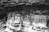
To the west of the Frontenac Axis, the Potsdam and Nepean Formations are the only Lower Paleozoic formations preserved below another major unconformity which developed prior to the deposition of the Middle Ordovician strata. The younger Lower Ordovician formations, March and Oxford, were quite likely deposited across the west of the Frontenac Axis, but the only evidence of their former existence west of the Axis is small, outcrops of lower March Formation just east of Clayton, New York. The period of erosion prior to the deposition of the Middle Ordovician strata in North America is commonly referred to as the Owl Creek discontinuity (Wheeler, 1963). This was an erosional period of considerable duration, and undoubtedly removed many feet of sediments from the area now occupied by the Frontenac Axis and westward across southern Ontario. East of the Frontenac Axis, the depth of erosion was not as extensive and so a thicker section of Lower Ordovician sediment remains, probably preserved as a downwarped basin occupying the St. Lawrence Lowlands. Following the period of erosion represented by the Owl Creek discontinuity, deposition of carbonate sediments resumed. In the St. Lawrence Lowlands, the initial deposits of the Middle Ordovician are known as the Ottawa Formation; in the areas immediately on and west of the Frontenac Axis, the early Middle Ordovician is divided into two formations, a basal green and red sandy shale, the Shadow Lake Formation, and the overlying limestones, the Gull River Formation (Liberty, 1961). The Shadow Lake Formation does not occur in all places below the Gull River Formation; it may represent a basal clastic unit infilling valleys and depressions in the Precambrian topography. The Gull River Formation is quite widespread, however, and in many localities rests unconformably on the granites and gneisses of the Precambrian (Liberty, 1971). An excellent exposure of the unconformable contact of the Gull River Formation and the Precambrian occurs on the west shore of Cedar Island, the most westerly island of St. Lawrence Islands National Park. At this locality, and also along the southwest shore of Old Fort Henry Hill, the basal limestone beds of the Gull River enclose angular blocks of the underlying Precambrian granites. The limestones exposed on Cedar Island are typical of the formation, consisting of brown, dark brown, and grey, very finely crystalline to lithographic limestones. Occasional shaley intervals occur between the thin- to medium-bedded limestones. Fossils are not particularly abundant in the lower members of the formation, but the upper beds contain a well-preserved Middle Ordovician fauna of brachiopods, corals, crinoids, bryozoans, trilobites, and ostracods. The entire formation is estimated to be from 280 to 300 feet (85.3-91.5 m) thick (Liberty, 1971). Glaciation [Top]
About 12,000 years ago, the final retreat of glacial ice occurred in the Thousand Islands area. The period during which the ice had frequently advanced and retreated across much of the temperate regions of the world is known as the Pleistocene Epoch, and it lasted at least a million years, and possibly as long as three million years. However, the events which initiated the long cooling that lead to the glacial period occurred over seventy million years ago, while dinosaurs still roamed the earth. The exact causes of glacial periods are not known, but there is general agreement on what factors contributed to the advent of glaciation. These factors include variations in (i) the amount of heat given off by the sun; (ii) the distance from the earth to the sun; (iii) the amount of heat arriving at the earth's surface, which is reduced by high concentrations of cloud and atmospheric or cosmic dust; (iv) the amount of heat reflected by the earth's surface; (v) the position of the earth's poles of rotation relative to the continents, and (vi) the extent of the continental seas and the height of the continental mountain ranges (Flint, 1971). The first two of the above factors are cyclic, and can be predicted. The amount of heat intercepted by cloud and dust, however, is randomly variable, and so this factor is not predictable. The amount of heat reflected by the earth depends on the types of materials present on the surface. Snow and ice tend to reflect heat, while rock and soil tend to retain it. Thus a continent-wide glacier tends to persist because it reflects away heat that, in non-glacial times, would be retained by the subglacial rock and soil. The position of the North and South Poles relative to the continents is a factor that may influence the growth or recession of glaciers. The poles of rotation of the earth are fixed in space, but the whole crust of the earth slides around continually. About seventy million years ago, the North Pole was just off the northeast coast of Siberia, and the Thousand Islands area was near the latitude of present-day Jacksonville, Florida. The continent of Antarctica was just beginning to slide over the position of the South Pole (McElhinny, 1973). When continents are over the position of either or both poles, the chances of extensive glaciation are increased. The last factor cited may be the most critical. In the late Mesozoic Era, shallow seas covered much of the present continents, and there were few high mountain ranges. However, changes occurred that initiated a long cooling trend. The floor of the Pacific Ocean began to subside, and the shallow seas that covered continental areas began to drain off into the deepening ocean basin. At the same time, mountain ranges began to rise around the world, the Rockies in North America, the Andes in South America, the Alps in Europe, the Himalayas in Asia and the Transantarctic Mountains in Antarctica. The disappearance of the shallow seas, which had acted to damp out extremes of temperature, would result in warmer summers and colder winters. The rising of the mountain ranges produced a general cooling of the earth, so that the limit of the winter snow cover migrated further and further south. At any one place, the snow also persisted longer into the spring. The high reflectivity of this snow lead to further cooling, and eventually to glaciation.
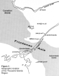
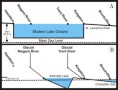
About ten million years ago, the average temperature of the earth may have been about 5º Celsius cooler than it was in Late Mesozoic times. Evidence from sediments cored from the ocean basins shows that a sharp drop in ocean temperatures occurred which suggests that a rapid cooling was taking place. Fossils from Antarctica show a sudden change from temperate to polar conditions as the world temperature dropped and the South Pole became more centrally located over Antarctica. Lava flows interlayered with glacially deposited material in parts of Antarctica have yielded ages by radioactive dating methods from about seven million years ago. The glacial age had begun, at least in Antarctica (Turekian, 1971). A temporary warming of the oceans occurred about four million years ago, but it was not sufficient to significantly reduce the size of the Antarctic ice sheet. The subsequent cooling that started about three million years ago lead eventually to the formation of major continental glaciers over great areas of North America and Europe (Turekian, 1971). Glaciers expanded across almost all of Canada in at least four separate and distinct stages. Between each glacial event, the climate warmed, and plants spread northward behind the retreating ice bounday. Soils formed on the glacial till, the debris left behind by the melting ice. In Canada, each new major glaciation swept away almost all evidence of the previous glaciers, and it is only in the central United States, near the southern limit of the glacial advances, that even a partial history of events has been worked out. The first major period of glaciation was called the Nebraskan Glacial Stage, and very little is known about it. Till of Nebraskan age is rarely exposed, and its distribution is known mainly on the basis of records from drill holes put down through younger till sheets. The distribution of Nebraskan till shows that the Thousand Islands area was ice covered at this time. The Nebraskan was followed by the warmer Aftonian Interglacial, and then by the Kansan Glacial State. Kansan till is well exposed in Missouri, lowa, Kansas, and Nebraska. Three cycles of minor advance and retreat have been detected in the United States, but, as yet no till of undoubted Kansan age has been found in Canada. Again, however, there is no doubt that the Thousand Islands area was glaciated by Kansan Ice sheets. The retreat of Kansan ice sheets led to the Yarmouthian Interglacial Stage which was followed by the advance of Illinoian age glaciers, into Ohio, Kentucky, Indiana and Illinois. This was probably the most severe glaciation, and it is possible that over 10,000 feet (3048 m) of ice covered the Thousand Islands region. The subsequent warming is known as the Sangamonian Interglacial State. During this time, the climate of the Thousand Islands region was similar to that of Virginia today. About seventy thousand years ago, renewed cyclic cooling resulted in the last major period of glaciation, the Wisconsin, which swept almost all evidence of previous glaciation away, depositing the rubble in the northern United States. As the Wisconsin ice sheet waned, a blanket of till was left over most of Canada. In a few places, the material formed by earlier glacial and interglacial process was not completely removed from Canada by the scouring action of Wisconsin ice. Thus, in the Don Valley of Toronto, material from the Illinoian and Sangamonian is exposed beneath the Wisconsin till sheets. The Illinoian till there lies directly on top of the glacially scoured bedrock. Although the sequence of the above events is well documented, the exact timing is not. Some researchers maintain that the Nebraskan ice sheet formed about four hundred thousand years ago, others place its formation at more than two million years ago. The dating of events in the Wisconsin, however, is reasonably accurate, because a remarkable technique, radiocarbon analysis, can be used to tell the age of almost anything that lived within the past forty thousand years. With special equipment, material seventy thousand years old can be dated. In the outer atmosphere, neutrons from cosmic radiation collide with nitrogen and produce a radioactive form of carbon (C14). This carbon acts like normal carbon (C12), and is fixed into plant material by photosynthesis: grazing animals pick up the C14 from the plants, and carnivores pick up C14 from the animals they feed on. Thus, there is a certain fixed amount of C14 in all living plants and animals. The one significant difference between C14 and C12 is that C14 slowly turns back into nitrogen again by emitting beta radiation. Once a plant or animal dies, it is no longer taking up C14 directly or indigectly from the atmosphere, and so the amount of C14 and, therefore, the amount of beta radiation begins to decrease. Six thousand years after its death, over half the radiation is so slight that special techniques are required to measure it, and after seventy thousand years, it is to all intents and purposes not detectable. This radiocarbon technique was discovered in 1950, and, all dates obtained by this method are reported in the number of years BP Originally, this meant Before Present, but to allow material dated in 1950 to be compared with material dated later, in 1975, for example, the term BP has come to mean "years before 1950 A.D.". Thus shells from the Ottawa area that yield radiocarbon dates of 10,600 BP indicate that the animal being dated was living at about 8,650 B.C. Mainly on the basis of radiocarbon dates, the Wisconsin Glacial Stage has been divided into three parts, the Early, Middle and Late Wisconsin Substages. The Early Wisconsin Glacial Substage lasted from about 70,000 to 55,000 BP The ice again covered the Thousand Islands area and reached well into the northern United States, with a maximum extent at about 60,000 BP During the following Middle Wisconsin Interstage, lasting from 55,000 to 25,000 BP, the ice front had retreated to the most northern parts of Ontario, but the ice apparently persisted over much of Quebec. The Thousand Islands area had a tundra-like climate. Most of the evidence of this cool but ice-free period is found in southwestern Ontario. In addition to beds of peat and fragments of wood, fossil mammoths, giant beavers, bear and caribou have been found in sediments deposited at this time. The Late Wisconsin lasted from 25,000 to 10,000 BP and during this time, the ice once more advanced across the Thousand Islands Area into the northern United States before a warming trend led to the final wastage of the ice (Flint, 1971). The ice ages ended at 10,000 BP, according to a group of experts meeting in Paris, in 1969, but at that time the ice front still lay just to the north of Quebec City, followed the Ottawa Valley north to Mattawa, and then stretched westward to the area of the Ontario-Manitoba border before curving northward. The period between 10,000 BP and the present is called the Recent, but until at least 8,000 BP, ice still covered the northern half of Ontario (Turekian, 1971). The period from 14,000 BP until 7,800 BP was a time of many complex changes. The ice front retreated northward and northeastward across Ontario, and as it did so the land, which may have been depressed as much as 2,500 feet (762 m), rose slowly as the weight of the ice disappeared. The normal drainage routes across Ontario were often blocked by ice and great lakes formed against the ice front. The sea, which had been lowered by over 400 feet (122 m) because so much of the earth's water was locked up in glaciers, began to rise as the glaciers melted. The rise in sea level was more rapid than the rise of the land, and so the sea flooded in behind the retreating ice in many coastal areas, and reached as far as Brockville about 11,500 years ago in an embayment called the Champlain Sea. Table 2 below outlines some of the complex events that occurred in southern Ontario during the period of deglaciation (Compiled by Gorman from many sources). The final deglaciation of Ontario began about 15,000 years ago in the Windsor area. A series of lakes formed between the massive ice barrier and the high land to the south. These lakes drained through the Ohio and the Grand Rivers to the Mississippi. The last of these lakes, Algonquin, covered the whole of Lake Erie basin, and parts of the Ontario, Huron and Superior basins, but was reduced considerably in size about 12,600 BP when the ice front retreated to a position north of Rome, near Syracuse, New York. This retreat opened a new low level drainage route for the waters of the Ontario Basin, and a new lake almost 300 feet (91.5 m) lower than Algonquin, Lake Iroquois formed between the Niagara escarpment and the ice front. Glacial Lake Algonquin spilled over the escarpment into Lake Iroquois at Queenston, Ontario, forming Niagara Falls. Since that time the falls have cut back about seven miles (11.2 km) to their present position, forming the Niagara gorge. Since the St. Lawrence valley was still blocked by ice, Lake Iroquois waters found their way to the sea by way of the Mohawk and Hudson Valleys. Continued retreat of the ice front finally opened up the St. Lawrence River Valley about 12,000 years ago and it is probable that the sea flooded most of the St. Lawrence lowlands, including part of the Thousand Islands area. At this point in the glacial history of the area, there is a divergence of opinion among investigators. One group believes that the land continued to rise from 12,000 BP to the present slowly spilling the seas out of the St. Lawrence Valley (Prest, 1970). A second group, noting C14 evidence that an Iroquois-like lake existed in the Ontario basin about 11,750 years ago, believe that at about 12,000 years ago the general warming trend was reversed for a few hundred years, and the ice advanced across the St. Lawrence River again, blocking off the sea near the mouth of the Saguenay and pushing up the north side of the Adirondack mountains southeast of Cornwall, Ontario to form an Iroquois-like lake (Frontenac?) for a few hundred years. The ice probably crossed southwestward across the Thousand Island area and extended some distance into Lake Ontario. Thus the Fort Covington Advance occurred at the same time as another short rapid re-advance was known to be occurring in the Lake Michigan basin. Around 11,500 BP, the ice front had again retreated to the north of the St. Lawrence River in the Cornwall area, and the water levels in the Ontario Basin dropped almost 300 feet (91.5 m), to form the Fort Ann Phase of Lake Vermont, because the level of this lake was controlled by a rock sill at the village of Fort Ann, N.Y., on the divide between the Hudson River and the Lake Champlain Basin. Most of the youngest freshwater clay deposits in the Thousand Islands area were probably deposited in this lake. Thereafter, uplift of the land gradually removed the sea from the area. The shore line of Lake Iroquois has been studied by many workers for almost one hundred years. There is no doubt that the shoreline is tilted with the lowest beach near Hamilton, Ontario, at an elevation of 360 feet (109.7 m) above present sea level, and the highest beach at Covey Hill, Quebec, about 30 miles (48 km) south of Montreal, at 1010 feet (307.8 m) above present sea level (Coleman, 1933). Since at the time of their formation, the beaches of Iroquois must have been horizontal, we know that the Montreal area must have risen 650 feet (198.1 m) more than the Hamilton area to produce the present day sloping beach. Since the outlet of Lake Ontario is near the end of the lake where the uplift has been greatest, the size of Lake Ontario has increased continually over the last 11,500 years. This process is demonstrated diagrammatically in Figure 2, showing why the early lake, known as the Admiralty Phase of Lake Ontario, was so small, and why the lake expanded considerably towards the west.
The Thousand Islands are developed on the Frontenac Axis where it crosses the St. Lawrence River. The Axis links Precambrian rocks of the great Canadian Shield to the Precambrian rock that forms the Adirondack Mountains. On the fringes and to the east and west of the Thousand Islands area, essentially flat-lying beds of Cambrian and Ordovician sedimentary rock produce a relatively featureless plain interrupted by local deposits of glacial debris. In the Thousand Islands area, however, the rock types are extremely varied, and while some, like marble, are easily broken up by weathering process and carried away, others, like granite, resist the erosive forces and tend to persist as hills. The Grenville orogeny mixed the hard and soft rocks into a complex 'stew' with lumps of the various types deposited haphazardly across the Axis area. Long continued weathering processes reduced the Precambrian rock complex to a gentle near-plain, which was covered by Lower Paleozoic sediments as the area sank below the sea. The uplifting of the arch resulted in the removal of much of the sedimentary cover, and the erosive process began to differentially remove the Precambrian rocks, producing an increasingly rugged landscape. This was the scene when the continental glaciers first invaded the area. These glaciers act somewhat like bulldozers, they tend to knock down the hills, and pile the debris in the valleys. In the process of wearing away the rock glaciers produce grooves, scratches and whalebacks, which are smoothed to form low bedrock outcrops. Many are seen rising a few feet above fields in the Thousand Islands area. At times, frost action on the down-ice end of higher whalebacks produces an assymetric bedrock outcrop commonly called a roche moutonnee. Many of the smaller Thousand Islands show this form. The debris broken off by glacial erosion may later be shaped into a stream-line hill called a drumlin. Although common in many parts of Ontario, only a few are to be found in the Thousand Islands area, mainly about 10 miles (16 km) west of Brockville, between Lyn and Athens. FIGURE 2 - The Ontario Basin
A. The Ontario Basin Today, B. The Ontario Basin at 11,500 BP Meltwater, flowing in tunnels under a glacier, deposits sand and gravel on the tunnel floor and against the ice in the area where it comes out from beneath the glacier. Surface streams may also deposit sand and gravel against the ice. The material deposited on the tunnel floor forms a long winding sand and gravel ridge called an esker. The other deposits, at the ice front, are called kames. A large esker forms the backbone of Grenadier Island, while a smaller one parallels the north central shore of Tar Island. Kame deposits are fairly common in the area. A very large kame near Lyn has been a source of sand and gravel for many years. A small kame is located at the east end of Brown's Bay (Henderson, 1971). The glacial lake that followed the retreating ice northeastward
across the Thousand Islands area deposited an unusual type of
sediment called varved clay. A light coloured layer deposited
in the summer alternates with a darker winter layer. This varved
lake clay is very common in low-lying areas west of the Ivy Lea
Bridge and can be seen at the top of several gravel pits in the
area. Almost none is found east of Brockville, suggesting that
the ice front stood in this area when the lake to the west drained,
stopping deposition of the varved clay. Structural Geology of the Thousand Islands Region [Top] The area occupied by the Thousand Islands region is part of a much larger structural complex described by Kumarapeli and Saull, (1966) as the St. Lawrence Valley System. These authors propose the structural hypothesis that the St. Lawrence Valley System, composed of the St. Lawrence, Ottawa, and Champlain Valleys, may form a rift system comparable to the rift system of East Africa. The evidence supporting this theory is persuasive, and, since its proposal, has received confirming data from recent seismological studies (Howell, 1973, 1975). Earthquakes are not unknown in the St. Lawrence Valley, especially in the vicinity of Quebec City, which only serves to emphasize that the region is not as tectonically stable has had previously been thought. The main tectonic or structural feature of the Thousand Islands region is the Frontenac Axis. The Axis is a narrow ridge of Precambrian rock which extends southeasterly from the Madawaska Highlands into the Adirondack Mountains of New York State. Lower Paleozoic sedimentary sandstones and limestones flank the Frontenac Axis to the southwest and northeast with occasional scattered patches of sedimentary rock distributed across its twenty-five mile (40 km) width. As previously described above, the Precambrian rocks of the Frontenac Axis are high grade metamorphic rocks of the Grenville Group. The Frontenac Axis may have been much less prominent a feature than it is at the present time. Two lines of evidence support a concept of gentle arching and uplift of the Frontenac Axis following Precambrian time. This uplift continued intermittently throughout the Early Paleozoic into the Middle Ordovician, and possibly later. Such uplift along the length of the Axis would account for the present topographic expression of the Precambrian rocks of the area, and otherwise anomalous distributions of the Lower Paleozoic formations. Evidence for uplift of the Frontenac Axis provided by Precambrian structure is summarized by Wynne-Edwards, (1962, marginal notes) "Northeast of the crest of the Frontenac Axis, in Westport map-area, the folds plunge northeast at an average of 35º. In Gananoque map-area, on the crest of the Axis or southwest of it, the folds most commonly plunge gently southwest. This difference must be due to the uplift of the Frontenac Axis itself". Distribution of the Lower Paleozoic formations over the Axis also supports this view of uplift. The older Paleozoic formations, Potsdam and Nepean, appear most commonly in outcrop on the top of the Axis, and across the southward extension of the Axis in New York State. The overlying Lower Paleozoic formations, March and Oxford, outcrop only along the northeast, and southwest flanks of the Axis. The exception to this general situation is an area of Paleozoic strata immediately south of Westport, Ontario where Nepean, March, and Oxford formations outcrop in a very small area. The general structural configuration of the Lower Paleozoic strata is that of a south-plunging anticline with the crest of the plunge coincident with the southeast trend of the Frontenac Axis. The northwesterly limb of this structure is not preserved; erosion during the period immediately prior to deposition of Middle Ordovician strata removed all trace of Lower Ordovician sediments in this area. Some remnants of Potsdam sandstone remain to the west of the Frontenac Axis, but to date these scattered patches of sandstone have not been studied in sufficient detail to document the existence in outcrop of the westerly limb of the above anticlinal structure. Mapping of the Paleozoic sediments in southeast Ontario has not been done sufficiently precisely as yet to enable the structural configurations of the Lower Paleozoic formations to be apparent. Unpublished field data by Bond and Greggs is the only documenting support for the above structural interpretation of the Lower Paleozoic. Herein lies one major field of geological research very much in need of study, not only for elucidation of the geological history of the area, but also for the more pragmatic applications to quarry operations, road construction, ground water resources and controls, and pollution studies. In addition to the proposed major feature in the Paleozoic sediments, the southeast plunging anticline, the sediments are disrupted in many sections by high angle faults, and gently to moderately dipping beds. Insufficient study has been made of these features to discern any structural pattern. These features, in all probability, are somehow related to the uplift and arching of the Frontenac Axis; only future study will solve some of these problems. The St. Lawrence River [Top] The St. Lawrence River was initiated slightly less than 12,000 years ago when the last high-level lake in the Ontario Basin drained and the waters fell to the level of Admiralty Lake. Admiralty spilled over a rock sill between Duck and Galloo Islands at a p6int about 30 miles (48 km) south of Kingston to form the proto-St. Lawrence River in a valley now cut into the bed of eastern Lake Ontario (Bowlby, 1975). In the area of Grindstone Island, this early St. Lawrence was joined by a much stronger river that was fed by the Upper Great Lakes and flowed through the Trent System, the Bay of Quinte, and the North Channel before joining the St. Lawrence. Both rivers had rapids and waterfalls where the water poured over ridges of resistant rock, and deep plunge pools were formed below the falls. For example, the bed of the St. Lawrence abruptly drops 100 feet (30.5 m) near Cape Vincent, and over 150 feet (45.7 m) along the Canadian Channel at the Ivy Lea Bridge. The early St. Lawrence emptied into the sea about ten miles (16 km) above Brockville. The uplift of the land following deglaciation caused the seashore to retreat eastward, and the St. Lawrence grew longer. Eventually, about 5,000 years ago, the rate of uplift slowed, and the river took on its present configuration. The waters of the St. Lawrence became very clear soon after deglaciation, for any sediment spilled into the system by fast turbulent streams soon settled out in the quiet waters of Lake Ontario. The advent of white man in the area did little to change the quality of the St. Lawrence waters initially. The clearing and plowing of the land may have caused a slight increase in the suspended and dissolved load of the waters, but it was so negligible that few changes were detected in the quality of the waters. Between 1900 and 1910, however, the amount of dissolved material in the water began to increase. By 1970, the chloride content has increased four-fold, potassium, sodium, and sulphate had doubled, and calcium had increased by one third (International Joint Commission, 1969). The increased content of dissolved nutrients has also led to a great increase in the amount of algae being produced in the Great Lakes, and algal matter entering the St. Lawrence has increased the turbidity and decreased the amount of dissolved oxygen, which is essential if fish are to live in the river's waters. Numerous villages sprang up along the St. Lawrence and often discharged sewage directly into the river. This not only increased the dissolved and suspended solids, it also created a health hazard. In the last few years, the situation has begun to improve. The use of high phosphate detergents has been banned in Canada, and this in time will reduce the algal population of the lakes. Most Canadian towns along the river now have sewage treatment facilities, and the amount of bacterial pollution appears be decreasing in a few areas. Unfortunately, four factors continue to mitigate against a return to the pristine state of the waters a century ago. First, the major source of dissolved pollutants is in the Detroit area, and relatively little is being done to improve the water treatment. Second, population density is increasing in the Great Lakes basin, and no matter how careful we are, more people means more pollution. Third, the dams at Cornwall and Iroquois, built to generate electricity and control the river flow, have decreased the flushing action that once occurred during the spring run off, and the amount of aeration of the waters has decreased. Finally, the sediments in the lakes and the river are enriched in pollutants, and as the waters of the system become purer, more pollutants will be released by the sediments. At the local level, careful use of an area can help prevent pollution. For example, in 1970 and 1971, a series of chemical tests on the waters around and beneath Cedar Island clearly established that the well water on the island was derived from rainwater falling on the surface and infiltrating to the well, and was not derived from the surrounding lake water (Johnston, 1972). Thus, care of the surface of the island will protect the well water's quality. In the long run, we have the ability to greatly improve the quality of the environment, and if enough people want it, and are willing to pay for it, ways can be found to improve the situation more rapidly than is presently being done. Economic Geology [Top] During the few hundred years of settlement of the Thousand Islands region, local rocks have been extensively used for building construction, road metal, and as sources of silica, lime, precious minerals, and metals, to mention a few of the more important applications. Many long-abandoned quarries and pits pockmark the Precambrian and Paleozoic rocks of the Frontenac Axis and adjacent areas. The mining operations in the Precambrian rocks were, for the most part, very small, almost one-family businesses. Some of the more interesting mines in the Precambrian exploited occurrences of gold, arsenic, iron, nickel, barite, mica, lead, molybdenum, graphite, slate, talc, and feldspar. These mines were located, as a rule, in small pegmatite masses, and thus were soon worked out. The pegmatite bodies are pod-lens-like in form, characteristically composed of very coarsely crystalline minerals, and rarely exceeded 100 feet (30.5 m) in greatest dimension. Pegmatities represent the last phases of crystallization of residual volatiles of a slowly cooling magmatic intrusion. The few Precambrian rocks now quarried are utilized as building stones, usually granite. A fine illustration of a relatively recent building constructed of the local Rockport granite is the Tourist Information Centre at Ivy Lea. Granite quarries were located on a few of the islands of the Admiralty Group, and on Tar Island, a small quarry was developed for mica enclosed in the local dark coloured schists and gneisses. Before commercially available plaster and lime was produced for house construction, the early settlers utilized Precambrian marble for the production of lime. These small operations were confined to areas of readily available marble, and were often developed solely for lime and plaster to be used in construction of one or two nearby dwellings. Most of these lime kilns are now completely overgrown, and very difficult to recognize to the inexperienced eye. In form, they measured some 10-15 feet (3.0-4.6 m) in diameter, with raised walls composed of blocks of marble, some 4-6 feet 1.2-1.8 m) high. By maintaining a fairly intense wood fire in the centre of this circle, the marble was slowly calcined. One such kiln is known be located on marble outcrops, and adjacent to old farm buildings; none is known in the Thousand Islands region. The Precambrian marble also provided minor amounts of lead, graphite, and mica. The economic use of the Lower Paleozoic sediments is limited to building stones, road metal, concrete aggregate, and silica. The brick red sandstones of the Potsdam Formation do not outcrop very extensively in southeastern Ontario, and they were never used as widely in house and government building construction in Ontario as compared to applications in Jefferson and St. Lawrence counties in northern New York State. Only one locality in Potsdam sandstone still continues to produce dimension stone for house trimming. This quarry is located on the east shore of the Rideau River west of Joyceville, Ontario. Most of the production of this quarry is now shipped to Toronto. A far more commonly used sandstone in the area was the sandstone of the Nepean Formation. Along the shores of the St. Lawrence River many old barns may still be seen with foundations composed of the yellow brown weathering Nepean sandstones. This sandstone was utilized for less mundane purposes in the Ottawa area, and many applications of the Nepean sandstone can be seen in the Parliament Buildings. The quarries providing this sandstone was located about one mile (1.6 km) east of the western end of the Queensway, west of Ottawa. These historic quarries have been filled in by the National Capital Commission, and the area is now used as a tent and trailer camping facility for Nepean Township. The Nepean Formation is also used as a source of silica for cement manufacture. The nearest, and probably the most extensive quarry of this type, is located on the north shore of the Bateau Channel, south of Pitts Ferry. The sandstones of the March Formation, even though very similar in composition to the Nepean sandstones, are not quarried for silica or building stone. The major application of the March sandstones is for road metal. Two such quarries are known in the Thousand Island region; one is just east and south of the Sherwood Springs overpass near the MacDonald-Cartier Freeway, which still produces some stone but is extensively flooded; the other, abandoned, is located near Whitney Point south of the Thousand Islands Parkway. These quarries are in the lower blue-grey March sandstones; no quarries are known developed in the upper, yellow-brown sandstones of the March Formation. The Oxford dolomite is a rather fine, attractive grey stone, and has been quarried in many localities, north and south of the St. Lawrence River for building construction. Most of these buildings are churches, but some of the older farmhouses of the area are constructed of this stone. No quarries are presently active in the Oxford Formation for production of building stone. Many quarries were developed, however, in the Oxford dolomites during construction of the MacDonald-Cartier Freeway for supplies of road metal. Quarries in occasional use in production of road metal and concrete aggregate are located north of Maitland, east of Smiths Falls, and east of Harlem. Many more are scattered throughout the area east and north of the Frontenac Axis towards Ottawa. In northern New York State, two very large quarries are producing from the Oxford (Ogdensburg) Formation. The larger, and deeper, of the two is located just south of Norwood; the other is in the western outskirts of Ogdensburg. The Gull River limestones, the so-called Kingston stone, were once very widely used as building stone. Many of the larger homes, government, and institutional buildings in Kingston are constructed entirely of this stone. No quarries are presently supplying building stone from the Gull River Formation. The entire production of the numerous quarries in this formation in the area west of the Frontenac Axis is for concrete aggregate and road metal. The unconsolidated material is of some economic importance to the area. Again, most of the deposits are small, and are operated as family businesses. All operations exploit sand and gravel deposits. Although the area has fairly extensive deposits of clay, and a few small marl deposits near Athens, none of these has been worked. Sand and gravel has been much in demand recently. The per capita consumption in the Toronto area increased four-fold between 1950 and 1968. In the latter year, consumption in Ontario reached 15.4 tons per capita (Hewett and Vos, 1970). The extraction of all this sand and gravel has resulted in many unsightly scars over the face of Ontario, where abandoned pits have become the receptacles for refuse. The Ontario government has recently passed legislation which requires pits that cease operation be rehabilitated so as to blend once again into the landscape. The rules were initially applied in the Toronto area with considerable success, and are being applied to more and more townships as time goes by. To date, no pits have been rehabilitated in the Thousand Islands region. The main sand and gravel deposits in the area are developed in the numerous isolated kames that dot the countryside. Eskers are exploited where present, but few occur in this area. Ancient beaches and river courses are also suitable for exploitation and several small pits are operating on these landforms. Boyles gravel pit just west of Highway 32, about one mile (1.6 km) north of Gananoque, is of minor economic importance, but displays many interesting geological phenomena. The bedrock floor exposed at several points exhibits a well-developed set of glacial scratches or striae that indicates that the ice was moving in a west-southwesterly direction when it last traversed the area. A sandy cobble till lies directly on the bedrock and is overlain by cross-bedded and rippled-marked outwash sands. A slumped-in section at the east end of the pit once displayed a river channel deposit and flame structure in these sands. Above this, a fine beach sand probably marks the inundation of the area by rising glacial lake waters (MacIlreath, 1969). These sands grade up into alternating sand-silt layers, then to silt-clay layers and finally to varved clays that were deposited in glacial Lake Frontenac. This sequence marks alternating summer and winter deposition at a time when the ice front was retreating northeastward from the Gananoque area. The varved clays contain several large boulders that were rafted to the area in icebergs, then dropped as the bergs melted. Secondary deposition of calcite has produced many concretions in the varved sequence. At the eastern end of the Thousand Islands region, a large pit in a kame deposit at Lyn displays a 20 foot thick coarse gravel deposit covered by up to 20 feet (6.1 m) of glacial till which contains several layers of stratified sand. A third large pit has been open in a kame deposit on Hill Island. Although mapped as a kame (Henderson, 1971), continued excavations of the pit have revealed the typical arched structure of an esker. In addition, the edges of the sand deposit slope very steeply, which is also typical of an esker. At the east end of the pit, a river channel has been cut into previously deposited sands and tills, and then infilled with river gravel. The lack of the common ridge-like form of eskers in this deposit may be explained by the fact that it has been extensively modified. In the southwest corner of the pit, the sand deposit is shown to have been progressively buried by a thick sequence of varved clays. These fine clays contain unusual 'pebbles', three inches (7.6 cm) in diameter, called concretions. These actuaIly grew in the sediments as circulating ground waters deposited layers of calcite on a seed fragment year after year. The calcite was picked up by the groundwater frorn fragments of limestone contained in the overlying sediments. Northward across the pit from the varved clay-concretion area, further evidence of the cementing action of circulating groundwaters in limestone-bearing sediments is seen. Glacial gravel, normally loose and runny, has been cemented into a hard rock called conglomerate. At the southeast edge of the pit, a very unusual sediment occurs. A gravel, made up of stones almost all about 1.5 inches (3.8 cm) in diameter, is set in a uniform fine sand. It is impossible that these two grain sizes could have been deposited together. The best explanation is that a beach deposit of uniform gravel with a lot of pore space (open-work gravel) later had the pore space infilled by sand filtering down from above. The 'beach gravel' is very close to the suspected elevation of the Champlain Sea shore in this area. In the higher levels of the pit, a concentration of very coarse boulders occurs in a single layer. This resembles a 'lag concentrate'. These boulders were once dispersed throughout finer material in a thick layer that once extended above the lag concentrate level, but wind or wave action picks up and moves the finer material to another site of deposition leaving only that material too heavy to move. The coarse material is concentrated as it lags behind. The coarseness of this layer suggest that wave action was responsible for its formation. The Precambrian bedrock exposed in the pit, a granite gneiss cut by pegmatite dykes and faults, is smoothed and striated by the action of the last glaciers as they moved south-southwest across the area. |
|
|